VesselConnect
  • Completed

    HS - 2022 - 18

    Nicholas R. Bates · BIOS

    he physical properties of the ocean from the surface layers to the abyssal water masses are changing in concert with natural and anthropogenically influenced physical forcing and sustained observations of the ocean are critically important to establish these rates of change. One of the longest open-ocean hydrographic stations in the world is maintained at the Hydrostation S site (formerly known as the Panulirus site) located about 25 km southeast of Bermuda in the North Atlantic Ocean. This repeat biweekly hydrographic observations was initiated by Henry Stommel and co-workers in 1954. Now, in its seventh decade, it continues to be recognized as one of the most important sustained ocean time-series and provides an invaluable metric for the long-term state of the North Atlantic subtropical gyre in relation to the meridional overturning circulation, western boundary transport, and gyre recirculation. For example, the upper ocean warming trend has strengthened (about 0.8° C since the 1970's) while the deep Labrador Sea has cooled by a few tenths of a degree. The signature of deoxygenation has been observed at Hydrostation S in the upper ocean (about 7 micro-moles/kg/decade decrease in dissolved oxygen) as well as an intensification and expansion of the oxygen minimum zone. These changes suggest that the North Atlantic subtropical gyre is experiencing deoxygenation as in the Pacific Ocean as a result of increased upper ocean stratification and reduced solubility of oxygen in warmer waters. The Hydrostation S program and its data set are managed as a service to the ocean community, being openly distributed and used as a resource in understanding processes and patterns of variability in the ocean, as well as for education, mentorship and outreach activities. The Hydrostation S project will contribute to the research and training of six research specialists and research technicians at BIOS and contribute to the research projects of at least three Ph.D. students through on-going educational partnership with Princeton University and the University of Southampton in the U.K. The one-day Hydrostation S research cruises are an ideal platform for testing new sensors and for providing hand-on training to undergraduate students enrolled in summer programs. The Hydrostation S project is designed to address the overarching hypothesis that the physical properties of the upper-ocean to deep-ocean are changing in concert with natural and anthropogenically influenced physical forcing. Sustained observations of the ocean, such as those from Hydrostation S, remain critically important to establish rates of change to provide quantitative empirical data for myriad regional and global ocean synthesis and modeling of ocean processes and future ocean change. The major objective of Hydrostation S into the seventh decade is to continue the frequent water column sampling of temperature, salinity, and dissolved oxygen (and indirectly, sampling of important ocean carbon time?series) of the North Atlantic subtropical gyre. Such work is complementary to other sustained observations such as the Bermuda Atlantic Time-series Study (BATS) and Ocean Flux Program (OFP). As for the past five years, two CTD profiles will be conducted to better capture the deep-water variability while maintaining all the previous discrete depths. The first CTD cast will profile to full ocean depth (3,200-3,500 m) while the second CTD cast will profile from the surface to 500 m to allow for biogeochemical instrumentation not rated for full ocean depth and to support ancillary studies of ocean physics, biological processes and biogeochemistry. A secondary objective will be to build upon the collaborative comparison of physical data collected as part of two autonomous sensor projects. In the latter stages of the project, as ocean glider deployment becomes more sustainable and reliable, collaborative and comparative efforts will be used to test the capability of ocean gliders to provide data of sufficient quality to detect long-term oceanic change in a "virtual" mooring time-series mode. The robust and highly accurate Hydrostation S data will be used to test the capability of emerging technologies over the next five to ten years.


    Sep 28 – Sep 29, 2022 · 1 d

    Off of Bermuda

    Sails with 1 other project

  • Completed

    HS - 2022 - 19

    Nicholas R. Bates · BIOS

    he physical properties of the ocean from the surface layers to the abyssal water masses are changing in concert with natural and anthropogenically influenced physical forcing and sustained observations of the ocean are critically important to establish these rates of change. One of the longest open-ocean hydrographic stations in the world is maintained at the Hydrostation S site (formerly known as the Panulirus site) located about 25 km southeast of Bermuda in the North Atlantic Ocean. This repeat biweekly hydrographic observations was initiated by Henry Stommel and co-workers in 1954. Now, in its seventh decade, it continues to be recognized as one of the most important sustained ocean time-series and provides an invaluable metric for the long-term state of the North Atlantic subtropical gyre in relation to the meridional overturning circulation, western boundary transport, and gyre recirculation. For example, the upper ocean warming trend has strengthened (about 0.8° C since the 1970's) while the deep Labrador Sea has cooled by a few tenths of a degree. The signature of deoxygenation has been observed at Hydrostation S in the upper ocean (about 7 micro-moles/kg/decade decrease in dissolved oxygen) as well as an intensification and expansion of the oxygen minimum zone. These changes suggest that the North Atlantic subtropical gyre is experiencing deoxygenation as in the Pacific Ocean as a result of increased upper ocean stratification and reduced solubility of oxygen in warmer waters. The Hydrostation S program and its data set are managed as a service to the ocean community, being openly distributed and used as a resource in understanding processes and patterns of variability in the ocean, as well as for education, mentorship and outreach activities. The Hydrostation S project will contribute to the research and training of six research specialists and research technicians at BIOS and contribute to the research projects of at least three Ph.D. students through on-going educational partnership with Princeton University and the University of Southampton in the U.K. The one-day Hydrostation S research cruises are an ideal platform for testing new sensors and for providing hand-on training to undergraduate students enrolled in summer programs. The Hydrostation S project is designed to address the overarching hypothesis that the physical properties of the upper-ocean to deep-ocean are changing in concert with natural and anthropogenically influenced physical forcing. Sustained observations of the ocean, such as those from Hydrostation S, remain critically important to establish rates of change to provide quantitative empirical data for myriad regional and global ocean synthesis and modeling of ocean processes and future ocean change. The major objective of Hydrostation S into the seventh decade is to continue the frequent water column sampling of temperature, salinity, and dissolved oxygen (and indirectly, sampling of important ocean carbon time?series) of the North Atlantic subtropical gyre. Such work is complementary to other sustained observations such as the Bermuda Atlantic Time-series Study (BATS) and Ocean Flux Program (OFP). As for the past five years, two CTD profiles will be conducted to better capture the deep-water variability while maintaining all the previous discrete depths. The first CTD cast will profile to full ocean depth (3,200-3,500 m) while the second CTD cast will profile from the surface to 500 m to allow for biogeochemical instrumentation not rated for full ocean depth and to support ancillary studies of ocean physics, biological processes and biogeochemistry. A secondary objective will be to build upon the collaborative comparison of physical data collected as part of two autonomous sensor projects. In the latter stages of the project, as ocean glider deployment becomes more sustainable and reliable, collaborative and comparative efforts will be used to test the capability of ocean gliders to provide data of sufficient quality to detect long-term oceanic change in a "virtual" mooring time-series mode. The robust and highly accurate Hydrostation S data will be used to test the capability of emerging technologies over the next five to ten years.

    Sep 28 – Sep 29, 2022 · 1 d

    Off of Bermuda

    Sails with 1 other project

  • Completed

    Blue Heron · UMN

    UMN cruise 2022 Gallup2

    Richard Ricketts · UMN

    These cruises utilize funding provided by the University of Minnesota. Chief Scientists will be completing seed research cruises or using their ship time to take graduate and undergraduate students on the research vessel Blue Heron.

    Sep 27, 2022 · 1 d

    Western Lake Superior

  • Completed

    Blue Heron · UMN

    UMN cruise 2022 Gallup1

    Richard Ricketts · UMN

    These cruises utilize funding provided by the University of Minnesota. Chief Scientists will be completing seed research cruises or using their ship time to take graduate and undergraduate students on the research vessel Blue Heron.

    Sep 26, 2022 · 1 d

    Western Lake Superior

  • Completed

    Atlantis · WHOI

    Volatiles: Chem/Bio

    David L. Valentine · UCSB

    This research project addresses the fate of hydrocarbons that enter the ocean, using geological oil seeps as a natural scientific laboratory. The key issues of intellectual merit that will be addressed focus on the development and application of methodology to determine how the chemical properties of hydrocarbon molecules dictate whether they will be trapped in the ocean's interior or find their way to the atmosphere. The research will further follow the fate of these molecules in the ocean's interior, determining how the ocean's bacterial population responds, and the extent to which responding bacteria will degrade these molecules. The broader impacts of this research will include the training of undergraduate and graduate students in scientific research and at-sea oceanographic training, as well as the dissemination of findings to policy makers striving to understand the fate and effects of hydrocarbons in the ocean.

    Sep 24 – Oct 9, 2022 · 15 d

    Gulf of Mexico operations to include work on the continental slope seeps, as well as a transect for water sampling to e.g., Saint Petersburg.

    Sails with 2 other projects

  • Completed

    Atlantis · WHOI

    ALVIN Engineering Dives

    Rick Chandler · WHOI

    Engineering dives associated with HOV ALVIN

    Sep 24 – Oct 9, 2022 · 15 d

    Gulf of Mexico operations to include work on the continental slope seeps, as well as a transect for water sampling to e.g., Saint Petersburg.

    Sails with 2 other projects

  • Completed

    Atlantis · WHOI

    Sentry 2022 Engineering Dives-German

    Sean Kelley · WHOI

    Sep 24 – Oct 9, 2022 · 15 d

    Gulf of Mexico operations to include work on the continental slope seeps, as well as a transect for water sampling to e.g., Saint Petersburg.

    Sails with 2 other projects

  • Completed

    Blue Heron · UMN

    UMN cruise 2022 Minor1

    Richard Ricketts · UMN

    These cruises utilize funding provided by the University of Minnesota. Chief Scientists will be completing seed research cruises or using their ship time to take graduate and undergraduate students on the research vessel Blue Heron.

    Sep 24, 2022 · 1 d

    Western Lake Superior

  • Completed

    Savannah · SkIO

    SEFIS

    Nathan Bacheler · NOAA

    SEFIS is a fishery-independent research group that surveys reef fish using traps and video from Cape Hatteras, NC, to St. Lucie Inlet, FL, from 15-115 m deep.

    Sep 24 – Sep 28, 2022 · 4 d

    Southeast US Atlantic continental shelf between NC and the east coast of FL.

  • Completed

    OOI Endurance Array OM Fall 2022

    Edward Dever · OSU

    Located in the Northeast Pacific Ocean off the coasts of Oregon and Washington, the Endurance Array is part of a regional observatory network that includes OOI, Station Papa, and Ocean Networks Canada. Measurements taken by this network collectively capture variability of ocean properties across a broad range of temporal and spatial scales. They allow examination of ocean health issues, including hypoxia, ocean acidification, and harmful algal blooms. The Coastal Endurance Array is made up of two cross-shelf moored array lines. The Oregon Line, off the coast of Newport, Oregon, is located at 44° 35’N, from 125°W to coast. The Washington Line, off Grays Harbor Washington, is located at 47oN, from 125oW to the coast. Gliders move and collect data around, along, and between these lines. Two Endurance Array sites include platforms connected to OOI’s Regional Cabled Array. The Coastal Endurance Array is designed to observe cross-shelf and along-shelf variability in the region. Each line contains three sites spanning the slope (~500-600 m), shelf (~80-90 m) and inner-shelf (~25-30 m). The three sites across the shelf and slope are associated with characteristic physical, geological, and biological processes. All six sites contain fixed sensors at the top and bottom of the water column paired with an adjacent water column profiler. The Oregon and Washington Lines are both affected by wind-driven upwelling and downwelling, but shelf stratification and upper-ocean properties are influenced differently by the Columbia River. The Washington Line is north of the Columbia River outflow and the Oregon Line is south of it. Observations on both sides of the river outflow allow for a greater understanding of regional coastal ocean ecosystem responses. Mooring lines provide synoptic, multi-scale observations of the eastern boundary current regime. Coastal gliders bridge the distances between the fixed sites and allow for adaptive sampling.

    Sep 21 – Oct 4, 2022 · 13 d

    Oregon and Washington shelf and slope

  • Completed

    GEODUC Course - Early Fall 2022

    Robert Kamphaus · UW

    The student cruise for GEODUC early fall quarter 2022 out of Friday Harbor Lab. NSF GEOPAth proposal for a summer bridge program. Participants in program are new transfer students from community colleges into UW CoENV Marine Sciences. The R/V Carson will be used to transport participants from the UW Seattle campus where they participate in intensive coursework to the labs. Participants will collect oceanographic samples and analyze environmental data en route.

    Sep 21 – Sep 24, 2022 · 3 d

    Puget Sound

  • Completed

    Ocean 200 Course - Fall 2022

    Robert Kamphaus · UW

    UW Oceanography Dept. Ocean 200 (Early Start) Student Cruise for 2022.

    Sep 20, 2022 · 1 d

    Puget Sound

  • Completed

    Savannah · SkIO

    DolMICROBE SEP 13/2022

    Marc Frischer · UGA

    The significance of doliolid microbial interactions: Do doliolids fundamentally alter the trophic structure and productivity of sub-tropical continental shelf food webs? The long-term goal of this project is to understand the ecological function of doliolids on subtropical continental shelves and their influence on microbial processes. In association with monthly oceanographic field expeditions on the mid-continental shelf at 31°N and two longer longitudinal expeditions complemented with experimental studies, the project investigates the relationship between doliolid abundance and life stage composition, their spatial relationships to marine snow aggregates and other zooplankton, water column microbial activity, bacterial production, and net system productivity. Utilizing a constellation of modern and classical approaches in microbial and zooplankton ecology, including deployment of an in situ zooplankton imaging system in the South Atlantic Bight, microbial metagenomics and transcriptomics, and stable isotope-based tracer experiments, these studies will allow the testing of three fundamental hypotheses. First, independent of total shelf productivity, the presence and abundance of doliolids is correlated with heterotrophy compared to periods when doliolids are not abundant. Second, doliolids predictably shape continental shelf microbial communities, activity, and function, and third, doliolids are detrital feeders benefiting nutritionally from the consumption of microbial enriched aggregated particles and fecal material - the pool to which they also contribute.

    Sep 19 – Sep 20, 2022 · 1 d

    Mid continental shlf of the SAB at 31 deg N between the 25 and 45 M isobaths

  • Completed

    HS - 2022 - 17

    Nicholas R. Bates · BIOS

    he physical properties of the ocean from the surface layers to the abyssal water masses are changing in concert with natural and anthropogenically influenced physical forcing and sustained observations of the ocean are critically important to establish these rates of change. One of the longest open-ocean hydrographic stations in the world is maintained at the Hydrostation S site (formerly known as the Panulirus site) located about 25 km southeast of Bermuda in the North Atlantic Ocean. This repeat biweekly hydrographic observations was initiated by Henry Stommel and co-workers in 1954. Now, in its seventh decade, it continues to be recognized as one of the most important sustained ocean time-series and provides an invaluable metric for the long-term state of the North Atlantic subtropical gyre in relation to the meridional overturning circulation, western boundary transport, and gyre recirculation. For example, the upper ocean warming trend has strengthened (about 0.8° C since the 1970's) while the deep Labrador Sea has cooled by a few tenths of a degree. The signature of deoxygenation has been observed at Hydrostation S in the upper ocean (about 7 micro-moles/kg/decade decrease in dissolved oxygen) as well as an intensification and expansion of the oxygen minimum zone. These changes suggest that the North Atlantic subtropical gyre is experiencing deoxygenation as in the Pacific Ocean as a result of increased upper ocean stratification and reduced solubility of oxygen in warmer waters. The Hydrostation S program and its data set are managed as a service to the ocean community, being openly distributed and used as a resource in understanding processes and patterns of variability in the ocean, as well as for education, mentorship and outreach activities. The Hydrostation S project will contribute to the research and training of six research specialists and research technicians at BIOS and contribute to the research projects of at least three Ph.D. students through on-going educational partnership with Princeton University and the University of Southampton in the U.K. The one-day Hydrostation S research cruises are an ideal platform for testing new sensors and for providing hand-on training to undergraduate students enrolled in summer programs. The Hydrostation S project is designed to address the overarching hypothesis that the physical properties of the upper-ocean to deep-ocean are changing in concert with natural and anthropogenically influenced physical forcing. Sustained observations of the ocean, such as those from Hydrostation S, remain critically important to establish rates of change to provide quantitative empirical data for myriad regional and global ocean synthesis and modeling of ocean processes and future ocean change. The major objective of Hydrostation S into the seventh decade is to continue the frequent water column sampling of temperature, salinity, and dissolved oxygen (and indirectly, sampling of important ocean carbon time?series) of the North Atlantic subtropical gyre. Such work is complementary to other sustained observations such as the Bermuda Atlantic Time-series Study (BATS) and Ocean Flux Program (OFP). As for the past five years, two CTD profiles will be conducted to better capture the deep-water variability while maintaining all the previous discrete depths. The first CTD cast will profile to full ocean depth (3,200-3,500 m) while the second CTD cast will profile from the surface to 500 m to allow for biogeochemical instrumentation not rated for full ocean depth and to support ancillary studies of ocean physics, biological processes and biogeochemistry. A secondary objective will be to build upon the collaborative comparison of physical data collected as part of two autonomous sensor projects. In the latter stages of the project, as ocean glider deployment becomes more sustainable and reliable, collaborative and comparative efforts will be used to test the capability of ocean gliders to provide data of sufficient quality to detect long-term oceanic change in a "virtual" mooring time-series mode. The robust and highly accurate Hydrostation S data will be used to test the capability of emerging technologies over the next five to ten years.

    Sep 16 – Sep 19, 2022 · 3 d

    Off of Bermuda

    Sails with 1 other project

  • Completed

    BATS 2022 - 9of12

    Nicholas R. Bates · BIOS

    Long-term observations over several decades are a powerful tool for investigating ocean physics, biology, and chemistry, and the response of the oceans to environmental change. The Bermuda Atlantic Time-Series Study, known as BATS, has been running continuously since 1988. The research goals of the BATS program are: (1) to improve our understanding of the time-varying components of the ocean carbon cycle and the cycles of related nutrient elements such as nitrogen, phosphorus, and silicon; and, (2) to identify the relevant physical, chemical and ecosystem properties responsible for this variability. In addition, the BATS program has strong and diverse broader impacts, contributing to the field of ocean sciences by providing high quality ocean observations and data for seagoing scientists and modelers, and a framework through which researchers can conceive and test hypotheses. This award will support the operations of the BATS program for five more years. The primary BATS research themes are as follows: (1) Quantify the role of ocean-atmosphere coupling and climate variability on air-sea exchange of CO2, and carbon export to the ocean interior; (2) Document trends and the controls on the interannual to decadal scale variability in carbon and nutrient cycles to their coupling in the surface and deep ocean via the Redfield Ratio paradigm; (3) Quantify the response of planktonic community structure and function, and impact on biogeochemical cycles to variability in surface fluxes and dynamical processes; (4) Facilitate development, calibration and validation of next generation oceanographic sensors, tools and technologies; and, (5) Generate a dataset that can be utilized by empiricists, modelers and students. This research integrates ocean physics, chemistry and biology into a framework for understanding oceanic processes and ocean change in the North Atlantic subtropical gyre. The existing 29 years of BATS data provide robust constraints on seasonal and interannual variability, the response of the Sargasso Sea ecosystem to natural climate variability, and signal detection of potential ocean changes. This project would extend the BATS program through years 31-35 to address a series of ten interlinked questions through integrated research approaches and a multitude of collaborative efforts. In addition to the themes above, and embedded into the ten questions and approaches, the BATS team will focus on, for example, coupling of particle production and biogeochemistry; revisiting the complexities of the biological carbon pump; oxygen decline; and changes in the hydrography, physics, ocean carbon cycle and biogeochemistry of the Sargasso Sea. The highest quality data observation and collection will be maintained and used to address these questions. Importantly, a wide range of collaborations at the BATS site, spanning the physical and biogeochemical disciplines, will aid these broad goals. Strong links to community stakeholders, and close collaboration (including methods intercomparisons and personnel exchanges) with the Hawaii Ocean Time-series are proposed. This work will extend the research findings of the project into educational and training opportunities within and beyond the oceanographic community, including training and mentorship of both undergraduate and graduate students.

    Sep 16 – Sep 19, 2022 · 3 d

    Off of Bermuda

    Sails with 1 other project

  • Completed

    Sally Ride · SIO

    SW MF Acoustics - Cruise 2

    William Hodgkiss · SIO

    Shallow Water Mid-Frequency Acoustics Co-PI William Kuperman SIO (858) 534-7990 wkuperman@ucsd.edu

    Sep 15 – Sep 22, 2022 · 7 d

    Pacific NW

  • Completed

    Defying Dissolution

    Amy Baco-Taylor · FSU

    Like their shallow-water counterparts, deep-sea corals provide structure and habitat that support a diverse community of invertebrates and commercially important fish species. However, as ocean acidification impacts the water chemistry of the surface and deep ocean, the future of deep-sea reefs is highly uncertain because ocean acidification makes it more difficult for corals to build the three-dimensional structure that these ecosystems depend on. The naturally harsh water chemistry conditions of the North Pacific are being exacerbated by ocean acidification therefore it was previously thought that deep-sea coral reef development could not occur in the region. Despite these expectations, reefs were recently discovered in the Northwestern Hawaiian Islands (NWHI) and the Emperor Seamount Chain (ESC), with 4 of 7 sites in waters that are corrosive to, or likely to dissolve, the coral skeletons that make up deep-sea reefs. With the discovery of these reefs, we have an unprecedented opportunity to investigate the potential impact of ocean acidification on these important ecosystems because, in contrast to previous studies, there is a gradient of water chemistry across our study sites, all at the same depth. This study will address basic questions regarding reef development in the deep sea, including: Can deep-sea coral reefs develop in water that is corrosive to coral skeletons? What is the fate of reefs that developed under supportive water chemistry conditions once they experience corrosive water? How long can reefs persist in corrosive water? Through addressing these questions, this study will provide critical insights into deep-sea reef formation, persistence, distribution, and the effects of ocean acidification on deep-sea coral communities. The investigators have a track record of partnerships with NOAA?s Deep-Sea Coral Research and Technology Program, and with the agencies actively making management decisions in this region for seamount deep-sea coral communities including the North Pacific Fisheries Commission and the International Seabed Authority. Results will be broadly circulated to the scientific community through publications, coral collections contributed to museums, and public databases. This project will contribute to developing a diverse and competitive STEM workforce through training of an underrepresented postdoctoral scientist, three graduate students, and undergraduate researchers. A partnership with WhaleTimes, Inc. will include ROV telepresence for the Creep into the Deep Program, K-12 School Visits, and e-books. Despite expectations that deep-sea scleractinian reefs could not exist under the harsh carbonate chemistry conditions of the North Pacific, reefs were recently discovered in the Northwestern Hawaiian Islands (NWHI) and the Emperor Seamount Chain (ESC), with 4 of 7 sites in waters undersaturated with respect to aragonite. The discovery of these reefs, with more than half the sites in undersaturated water, provides an unprecedented opportunity to investigate the potential impact of ocean acidification on these important ecosystems. It is becoming critical to gain a better understanding of the role of aragonite saturation in the distribution of deep-sea scleractinian reefs because it has been documented that the aragonite saturation horizon (ASH) is shoaling throughout the world oceans due to ocean acidification. More deep-sea reefs will experience undersaturation in the near future as aragonite saturation declines and the ASH shoals, making the future of deep-sea reefs and the ecologically and economically valuable ecosystems they support highly uncertain. Building on the discovery of deep-sea coral reefs in the NWHI and ESC, the overarching question of this project is: How is it that deep-sea scleractinian coral reefs can occur in undersaturated water, well below the hypothesized reef development limit Although individual corals may be capable of calcifying in undersaturated water, it is unlikely that a three-dimensional reef structure could develop since deep-sea calcification rates are slow and most of the reef matrix is dead skeleton susceptible to dissolution. Therefore the hypotheses to be tested are: 1) These deep-sea reefs developed in saturated water and are now in undersaturated water because the ASH has shoaled; 2) The reefs in undersaturated water are now net dissolving; and 3) Environmental parameters other than aragonite saturation are driving reef distribution. To test these three hypotheses, we plan two research cruises to characterize the reefs and environmental parameters of nine seamounts across an aragonite saturation gradient where reefs exist above and below the ASH. Coral and water samples will be collected, an ROV will conduct video transect surveys, and experimental dissolution blocks and in situ instrumentation will be deployed at the reef sites to investigate: carbonate chemistry variability on diel (in situ instruments) to centennial (skeletal boron isotopes as a pH proxy) scales, calcification and dissolution rates, and reef ecology. Further, species distribution modeling will be used to examine the environmental factors that determine the distribution of these deep-sea reefs.

    Sep 15 – Oct 30, 2022 · 44 d

    NWHI/Emperors Seamounts in the far Northwestern Hawaiian Islands and Emperor Seamount Chain, following along the Hawaiian Ridge

  • Completed

    Sikuliaq · UAF

    AMOS 2022

    Craig Lee · UW

    Service moored, autonomous and ice-based assets for the AMOS program.

    Sep 14 – Oct 27, 2022 · 43 d

    central Beaufort Sea Op Area Size?Dia.: 300

  • Completed

    Neotrypaea Project2

    Clare Reimers · OSU

    Changing environmental conditions in shelf waters along OR & WA have included increasingly frequent and severe hypoxia events, ocean acidification, and warming. Following the Marine Heat Wave of 2015, we documented an abundant mid-shelf population of the burrowing ghost shrimp, Neotrypaea sp. Neotrypaea were previously known as ecosystem engineers of intertidal estuary mudflats and as an insignificant presence in the open ocean. The abundant Neotrypaea in estuaries continuously rework the sediment via their burrowing activities. Their burrowing is important in mitigating impacts of nutrient loading (natural and anthropogenic), which can exacerbate low oxygen conditions, as well as increasing oxygen cycling due to burrow irrigation. However, enhanced benthic oxygen consumption linked to Neotrypaea sp. beds may further intensify regional hypoxia on the shelf. We will characterize the environmental conditions under which these burrowing shrimp presently occur to base predictions of habitat suitability modeling. We will ground-truth the model predictions via box coring and video lander observations. The benthic samples will track changes in potentially interacting benthic invertebrate communities within the Neotrypaea beds. We will estimate the shrimp’s contribution to benthic oxygen and organic carbon cycling by analyses of aquatic eddy covariance and of core incubations in shelf areas with and without abundant shrimp. Finally, we will determine how these shrimp and the abiotic and biotic impacts of their burrows change the overall productivity of the mid-shelf benthos relative to reference areas. The offshore distributions and impacts of these ecosystem engineers must be characterized as they may stabilize the food supply for higher trophic levels, impact fisheries, and significantly alter seafloor structure and biogeochemistry.

    Sep 14 – Sep 19, 2022 · 5 d

    OR-WA shelf

  • Completed

    Endeavor · URI

    NE Soundscapes

    Christopher Roman · URI

    The New England Seamount (NESM) Pilot Soundscapes Cruise ~May 2022 is part of the Task Force Ocean Department Research Initiative to study the Atlantis II cluster of the New England Seamount Chain. This cruise shall coordinate with the R/V Neil Armstrong, which shall be collecting complimentary oceanographic measurements near the seamount. The Soundscapes Cruise will conduct simultaneous passive acoustic and biological surveys including ship-based EK60 surveys, towed wire flyer surveys, deployment and recovery of optical-acoustic midwater drifters, moored acoustic array placement and recovery, and targeted MOCNESS trawls. The goals are to characterize the ambient soundscape associated with seamount communities including deep reefs and fish aggregations, and to map the distribution of midwater and pelagic biology around the seamount cluster and in relation to oceanographic features such as eddies.

    Sep 13 – Sep 23, 2022 · 10 d

    NE Seamounts

  • Completed

    2022 Jason Eng Dive - Hawaii

    Matt Heintz · WHOI

    Jason engineering dive days in 2022. 2 days in front of KM/ Baco Taylor (preferably a stand alone prior to Amy’s cruise) And if there could be a pit stop mid-way through Baco Taylor to do a Jason staff change that would be ideal, but not required (my guess is it’s probably not possible endurance wise)

    Sep 12 – Sep 15, 2022 · 2 d

    Prior to Amy Baco-Taylor Defying Dissolution

  • Completed

    WOAC-2022-Fall

    Robert Kamphaus · UW

    Sep 12 – Sep 17, 2022 · 4 d

    Puget Sound

  • Completed

    QCF

    Lindsay Worthington-OLD ACCOUNT · TAMU

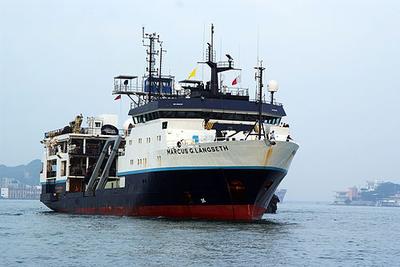
    Often called the "San Andreas of the North", the Queen Charlotte fault (QCF) system is a strike-slip plate boundary that separates the Pacific and North American tectonic plates offshore western Canada and Southeast Alaska. The QCF is arguably the most active fault of its type in the world: the entire ~900 km offshore length has ruptured in seven >M7 earthquakes during the last century and it sustains the highest known deformation rates (>50 mm/yr). The fault system represents the largest seismic hazard to southeastern Alaska and Canada outside of Cascadia, and caused Canada?s largest recorded earthquake (M8.1) in 1949. Despite rapid response efforts following >M7 earthquakes in 2012 and 2013, first-order questions regarding how the fault system deforms and the processes controlling fault failure during earthquakes remain unanswered due to the lack of modern geophysical imaging. This experiment will be the first comprehensive attempt to characterize this plate boundary at depth on a regional scale. Using seismic energy from marine acoustic and earthquake sources, the project will measure the depth and extent of seismicity, image the fault zone at depth, and determine velocity and thermal structure across the fault. All these data will lead to an improved understanding of this, and other major strike-slip fault systems, for better hazard assessment and earthquake forecasting. The science team is a collaborative, international group of US and Canadian researchers, led by three early-career women. Outreach to local communities will be conducted through a residency at the Sitka Science Center in Alaska and lectures at local high schools and community centers. Compared to convergent continental-oceanic plate boundaries, the time-space evolution of continental-oceanic transform margins is understudied, despite their important role in the planet?s plate tectonic system. Continental-oceanic transform faults are potentially one of the most favorable tectonic settings for subduction initiation due to the juxtaposition of lithospheres of contrasting density and thermal structure -- small degrees of convergence can lead to failure. The QCF system provides an ideal location to investigate how a continental-oceanic transform fault responds to systematically increasing degrees of convergence at the lithospheric scale. The study area includes two potential fault segment boundaries that mark abrupt changes in transpressive deformation mechanisms as suggested by changes in seafloor morphology and shallow seismic reflection structure: strain partitioning and underthrusting in the south transition to highly localized strike-slip deformation in the north. Lack of information on microseismic depths and locations, the deformation history and geometries of faults at depth, and lithospheric velocity structure leave multiple fundamental questions unanswered: Why has the QCF formed where it is, and what is its deformation history? What is the history of PAC underthrusting along the margin and the fate of underthrust material north of the area of maximum convergence? What are the primary physical conditions controlling seismogenesis along oceanic-continental transforms? How are strike-slip and compressive strain accommodated and partitioned over geologic and seismogenic timescales? Using a combined active- and passive-source marine seismic imaging strategy, this research will characterize crustal and uppermost mantle velocity structure, fault zone architecture and rheology, and seismicity. Data will be acquired using long-offset 2D seismic reflection and wide-angle reflection-refraction capabilities of the R/V Marcus G. Langseth and a combined US-Canadian broadband ocean bottom seismometer array of 64 instruments deployed for ~1 year.

    Sep 10 – Sep 19, 2022 · 9 d

    SE Alaska. Continental shelf and slope offshore SE Alaska and British Colombia

  • Completed

    Pelican · LUMCON

    MRDF Mudflows

    Jason Chaytor · USGS

    This project is a continuation of previous data collection activities on the Mississippi River Delta Front and contributes to an ongoing multi-Federal agency effort to evaluate the current surfical extent, event history and impact on seafloor pipelines/platforms of mudflows in Mississippi Delta region. These data will provide the essential framework for future sampling, modeling and monitoring activities.

    Sep 9 – Sep 23, 2022 · 14 d

    Mississippi River Delta Front

  • Completed

    Savannah · SkIO

    DolMICROBE SEP, 1 2022

    Marc Frischer · UGA

    The significance of doliolid microbial interactions: Do doliolids fundamentally alter the trophic structure and productivity of sub-tropical continental shelf food webs? The long-term goal of this project is to understand the ecological function of doliolids on subtropical continental shelves and their influence on microbial processes. In association with monthly oceanographic field expeditions on the mid-continental shelf at 31°N and two longer longitudinal expeditions complemented with experimental studies, the project investigates the relationship between doliolid abundance and life stage composition, their spatial relationships to marine snow aggregates and other zooplankton, water column microbial activity, bacterial production, and net system productivity. Utilizing a constellation of modern and classical approaches in microbial and zooplankton ecology, including deployment of an in situ zooplankton imaging system in the South Atlantic Bight, microbial metagenomics and transcriptomics, and stable isotope-based tracer experiments, these studies will allow the testing of three fundamental hypotheses. First, independent of total shelf productivity, the presence and abundance of doliolids is correlated with heterotrophy compared to periods when doliolids are not abundant. Second, doliolids predictably shape continental shelf microbial communities, activity, and function, and third, doliolids are detrital feeders benefiting nutritionally from the consumption of microbial enriched aggregated particles and fecal material - the pool to which they also contribute.

    Sep 8, 2022 · 1 d

    Mid continental shlf of the SAB at 31 deg N between the 25 and 45 M isobaths

  • Completed

    PNW Foram Ecology 3 of 4

    Jennifer Fehrenbacher · OSU

    The project will improve the utility of temperate and high-latitude planktic foraminifera in paleoclimate research and quantify the effects of modern climate change on foraminifera assemblages in the Northeast Pacific Ocean. The main objectives are to expand our knowledge of the ecology and environmental controls on the geochemistry of temperate and higher-latitude foraminifera species, quantify their response to modern changes in oceanographic conditions (specifically marine heat waves), and constrain foraminiferal geochemical signatures as they sink to the seafloor. This will be achieved through a significant field-based and laboratory effort that includes newly collected plankton tows, short-duration ship-based culture experiments, assemblage data from archived plankton tow samples, and the deployment of two moored sediment traps. The proposed multi-pronged sampling strategy will provide critical samples needed to understand the biogeochemistry and ecology of foraminifera in this important ocean margin region, increase their utility in understanding past oceanographic conditions, and lay the groundwork for understanding how high-latitude species will respond to future climate change. Highly controlled culture experiments will quantify trace element incorporation dynamics and mechanisms responsible for intrashell trace element variability in temperate to polar species. The results of these experiments will offer important information that can be used to interpret the geochemistry of fossil foraminifera in temperate to high-latitude regions, broaden our understanding of the controls on trace element incorporation in high-latitude and temperate foraminifera species, and improve their utility in paleoceanographic reconstructions. Sediment trap, plankton tow, and cultured specimens will be analyzed for their trace element and isotopic composition. Live captured specimens will be analyzed to determine their genotype and microbiome. Foraminifera and sediment trap samples not used by the PIs in this project will be archived at the OSU Marine Geological Repository for future studies by the scientific community.

    Sep 7 – Sep 12, 2022 · 5 d

    Recover and redeploy sediment traps near the NH line. Sample water column between NH 45 and NH 150

  • Completed

    Blue Heron · UMN

    EPA - 3rd 2022 cruise

    Richard Ricketts · UMN

    Due to necessary engine repairs on the EPA R/V Lake Guardian , EPA plans to procure vessel support in April and May 2022 (up to 19 days total) to conduct GLNPO’s mission-critical spring water quality and biology monitoring survey of Lake Superior, Lake Michigan, and Lake Huron and in September 2022 (up to 15 days total) to conduct GLNPO’s mission-critical summer water quality and biology monitoring survey of Lake Superior and Lake Huron. This survey helps EPA fulfill monitoring and assessment commitments specified in the Great Lakes Water Quality Agreement between Canada and the United States and in the U.S. Clean Water Act. EPA uses data from the spring and summer surveys to assess the status of overall water quality and lower food web health at a whole-lake scale.

    Sep 7 – Sep 21, 2022 · 14 d

    Lakes Superior, Michigan and Huron

  • Completed

    Axial Eruption Cycle-Deploy

    William Wilcock · UW

    Volcanic eruptions are one of the most important processes that shape the Earth?s surface. However, eruptions are difficult to study up close because they are so destructive. The deep seafloor provides an opportunity to collect detailed observations of eruptions immediately atop a volcano. Since 2014, the NSF Ocean Observatories Initiative has operated a cabled observatory in the southern half of the summit caldera of Axial Seamount, an active volcano located 300 miles off the coast of Oregon. In 2015, the volcano erupted and the records from cabled instruments provided many insights. Among these insights were improvements in forecasting eruptions. Axial Seamount is rapidly inflating, and another eruption is now predicted in a few years. This proposal will operate 15 remote seafloor instruments for earthquake detection. Over 2 years the project will seek to record the next eruption. These new observations will improve understanding of how magma and fractures interact in volcanoes. Such interactions create the pathways of magma to the seafloor. This experiment is part of a broader effort in the volcano science community to develop Community Experiments. These experiments include different kinds of eruptions. Through the comparison of the different eruptions scientists will improve the understanding of volcano hazards. The data from this project will be available to all of the public. Among the science community this data sharing will help scientists interpret geological, hydrothermal and biological observations from submarine volcanoes.

    Sep 3 – Sep 8, 2022 · 5 d

    Summit of Axial Seamount

NewerPage 47 of 55Older