VesselConnect

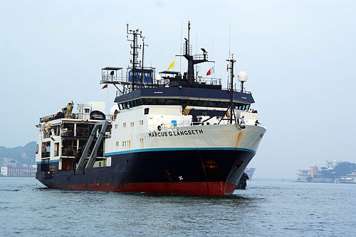
Marcus G Langseth

UNOLS · Lamont-Doherty Earth Observatory, Columbia University

Loading map…

Oct 2025 – Sep 2026 · 14 port calls · 145 at-sea periods

35

Research bunks

71 m

Length

11 kn

Cruise speed

13500 nm

Range

Projects

12+ past · 1 upcoming

Completed

IMPULSE

Stephen Jones · Birmingham

The mantle is the largest component of the Earth, comprising 84% of our planet's volume. Although the mantle is solid, over geological time it churns vigorously like a fluid in a process known as mantle convection, driven by heating from radioactive decay in Earth's interior and cooling from above. Mantle convection deforms the Earth's entire surface into an interlocking pattern of swells and depressions known as "dynamic topography", with diameters of several thousand km and heights of several km. Dynamic topography influences oceanic current patterns, land surface erosion and accumulation of the eroded sediment, and these effects are known to control the distribution of valuable natural mineral resources. Volcanic activity also usually occurs in association with the hot, rising elements of the convective circulation, known as mantle plumes. The most vigorous mantle plumes give rise to Large Igneous Provinces (LIPs) - episodic huge outpourings of lava accompanied by voluminous release of greenhouse gases to the atmosphere. LIPs coincide in time with some of the most remarkable perturbations to global climate, ecosystems and the carbon cycle in Earth's history, including mass extinctions, Ocean Anoxic Events, and the largest natural global warming event of Cenozoic time. Whilst it is widely accepted that mantle convection has influenced Earth's surface and climate processes over geological time periods (tens of millions of years or more), these time frames are too slow to explain the rapid onset and short duration of the environmental changes that usually coincide with LIPs. But growing evidence now suggests that patterns of mantle convection, dynamic topography and igneous outpouring can evolve in less than a million years. Key to this theory is a process known as "Thermal Plume Pulsing", in which hotter and cooler blobs of mantle are carried along with the convective circulation within a mantle plume. The hottest pulses within the biggest mantle plumes, such as the Icelandic Mantle Plume, can rise at speeds in excess of 200 mm/yr, which is faster than the motion of tectonic plates, and can cause changes in local sea-level of over 1 mm/yr, similar to modern mean global sea-level change. At such speeds, past pulsing of the Icelandic Mantle Plume could have activated greenhouse gas generation from the North Atlantic LIP rapidly enough to explain the Paleocene-Eocene Thermal Maximum extreme global climate change event, the best natural analogue to anthropogenic climate change. However, the Plume Pulsing hypothesis is not universally accepted for Iceland or Earth's other major mantle plumes as key data is lacking. High-quality measurements of seafloor features near Iceland known as the "V-Shaped Ridges" (VSRs) that comprise the world's best record of the suggested hot pulses will address this gap. Working with the lead advocates of the alternative models for VSRs, we have devised an experiment to determine the origin of the VSRs by measuring both the thickness and the chemical composition of the crust that builds the VSRs. High-quality geochemical surveys of the basaltic seafloor were made recently by dredge sampling and drilling (International Ocean Discovery Program Expedition 395). Now, IMPULSE will measure the variation in thickness and seismic velocity (hence bulk composition) of the entire crust beneath several VSRs for the first time. Joint modelling of the co-located seismic data and geochemical data will then allow the first definitive test of the Mantle Plume Pulsing hypothesis. Furthermore, by formally correcting for the complicating effect of mid-ocean ridge tectonic processes on VSR crustal thickness for the first time, our new VSR record will determine the shortest time period for fluctuations in mantle temperature. These results are crucial to test hypotheses for how mantle convection has influenced Earth's surface and climate proceses.

Aug 4 – Sep 9, 2024 · 36 d

North Atlantic, Reykjanes Ridge

Completed

Chain Cruise 1

Jessica Warren · UDel

This collaborative project is to explore the structure, seismicity, rheology, and magmatism within the slow-slipping Chain Transform Fault in the equatorial Atlantic. The formation of localized zones of deformation is a key attribute of plate tectonics. Oceanic transform faults are ideal laboratories for studying the mechanisms of localized deformation due to their relatively uniform composition and predictable motion. Many aspects of strain accommodation remain poorly understood, including (1) the extent to which cracking and seawater-driven reactions cause fault weakening deep into the fault, (2) the role of serpentine and other phyllosilicates in accommodating aseismic creep, and (3) the importance of melt infiltration and weakening within the fault zone. While existing samples of transform faults provide constraints on strain weakening mechanisms, very little sampling has been done in concert with the collection of structural and seismicity data to directly link fault behavior to rheology. An interdisciplinary field program to study the structure, composition, and seismicity of the Chain Transform Fault will be conducted through two research cruises. The first cruise, aboard the R/V Langseth, will collect multi-channel seismics to image sub-surface fault structures and the extent of magmatism in the fault domain. An ocean bottom seismometer array will be deployed during the cruise to determine the depth extent of microseismicity and the relationship between fault structures and seismicity. The second cruise will occur one year later to recover the OBS array. This cruise will dredge the fault zone to determine the composition and rheology of the fault and conduct surveys using AUV Sentry to identify the surface expression of the fault.

Nov 20 – Dec 19, 2024 · 29 d

Equatorial Atlantic at 1.5S and 15W.

Completed

Chain Cruise 2

Jessica Warren · UDel

An interdisciplinary field program to study the structure, composition, and seismicity of the Chain Transform Fault. An ocean bottom seismometer array was deployed in Nov 2025 to record microseismicity on the fault. These OBS were scheduled for recovery in Oct/Nov 2025, but are now being recovered in Mar 2025, 8 months ahead of schedule due to the OBS recall by NSF.

Mar 16 – Mar 29, 2025 · 13 d

Equatorial Atlantic at 1.5S and 15W.

Completed

Impact of Chemical Signaling on bloom BGC

Bethanie Edwards · Berkeley

Here we propose a field expedition with a series of deck-board incubations to assess the effects of oxylipins on community trophic and biogeochemical dynamics, in the California Current Ecosystem (CCE). Oxylipins are a class of lipid derived chemical signals produced by diatoms and other eukaryotic phytoplankton under stressful circumstances such as nutrient limitation, wounding due to grazing, and viral infection. From culture and laboratory-based amendment experiments, we know that oxylipins decrease the grazing rates of microzooplankton (MZP), decrease the reproductive success of copepods, decrease the growth rates of eukaryotic phytoplankton and free-living bacterial isolates, and stimulate diatom and particle associated bacteria. Since oxylipins are produced under stress conditions associated with bloom decline and their bioactivity radiates throughout the food web, we hypothesize that oxylipin chemical signaling impacts the biological and microbial carbon pumps through trophodynamics, allelopathy, and stimulation of particle degradation. The major questions that we will address include: 1) how does the concentration and suite of oxylipins available for signaling change over the course of a bloom? 2) what is the net impact of oxylipin signaling on community dynamics? 3) can we quantify the impact of oxylipins on carbon export and nutrient recycling (N, P, Si) in the system? This work will consist of a three-week cruise that seeks to follow diatom blooms off the Coast of California from the onset of the bloom to their demise while surveying the oxylipins dissolved in the water column, particulate oxylipin concentrations, and the oxylipins associated with sinking particles. We will also conduct a series of deck-board experiments with natural populations to determine the net effect of oxylipin chemical signaling on community dynamics and C, N, P, and Si biogeochemistry.

May 30 – Jun 15, 2025 · 16 d

California Current Ecosystem

Completed

Microbial energy

Kimberly Popendorf · UMIAMI

Microbial growth efficiency (MGE) is a critical ecological parameter that describes the amount of energy required for biomass production and defines the proportion of carbon lost from marine microbial foodwebs through respiration. Despite its significance our understanding of the ecological and biological drivers of MGE is poor. Our proposed work will address this need by developing critical new insights into MGE in the global ocean: identifying the ecological conditions and microbial taxa that account for the variance in MGE along a nearshore-offshore gradient. We will make these measurements using an innovative combination of two new tracer-based techniques, along with flow cytometry and microbial community structure analysis. We will use machine learning techniques - currently underutilized in microbial ecology - to provide predictive analytics and link microbial community structure, microbial abundance, and microbial activity. To carry out our study we will conduct a cruise in the California Current ecosystem along the central and southern California coast, a well-characterized and heterogenous region that is broadly representative of key ecosystems in the global ocean. Our proposed effort is a new collaboration between three early career researchers representing biological and chemical oceanography. We will leverage the intrinsic societal importance of this work to carry out a program of education and outreach at multiple levels.

Jun 19 – Jul 10, 2025 · 21 d

California Current ecosystem, from San Diego to Point Sur and return

Completed

Transit Cruise

Jesus Gaytan · LDEO

Jul 16 – Jul 27, 2025 · 11 d

Completed

Nutrient-Plankton System

Harvey Seim · UNC

We propose a combined field and laboratory program with a modeling effort to evaluate if different physical modes of nutrient delivery, in close proximity to each other, exert sufficient controls on nutrient availability and influence phytoplankton functional biodiversity and that of their zooplankton grazers. Distinct mechanisms have been identified that enhance nutrient concentrations to the upper ocean, but which are expected to support different rates and time histories of nutrient delivery. We hypothesize that varying physiological traits of phytoplankton nutrient acquisition and storage will conform to these inputs. The proposed study site is the Galápagos Archipelago in the eastern equatorial Pacific Ocean. Measurements collected there by members of our team since 2014 suggest three modes of nutrient delivery are operative (topographic upwelling, island wakes and internal tides), and that phytoplankton communities differentially respond to these modes. For this proposal, intensive shipboard sampling will be augmented by 12-month deployments of a vertical profiler mooring to observe i) an isolated island wake and ii) interaction of the archipelago with the Equatorial Undercurrent (EUC) and upwelling on the western side of the archipelago. Internal tides are believed to have a significant influence on the system and also will be observed. The longer-term observational efforts will generate time series of currents, hydrographic properties including nitrate and chlorophyll a fluorescence and include biweekly water sampling of the region for molecular characterization of the phyto- and zoo-plankton communities. Intensive shipboard surveys will additionally measure a suite of hydrographic and plankton properties, including community composition, primary productivity, nutrient uptake rates and changes in gene expression driven either directly or indirectly by the physical forcing. Laboratory culture studies using phytoplankton isolates obtained from the region will be used to characterize nutrient uptake and storage characteristics to complement the field studies. The result will also inform parameterization of a simple plankton model forced by time series of nutrient delivery representative of the three physical modes at play, used to test if bottom-up control can explain observed distributions and temporal variability. A suite of phytoplankton parameterizations will be investigated, informed by observed species-specific characteristics, to determine which phytoplankton functional traits are favored by which physical mode. The overarching goal of the project is to examine how these specific physical mechanisms influence the functional biodiversity of plankton communities through increasing nutrient inputs into the mixed layer, leading to strong, yet perhaps predictable biological variability in a changing ocean environment.

Jul 30 – Aug 20, 2025 · 21 d

Galapagos Archipelago

Completed

GTJ_OBS 1 of 4 cruises

Zachary Eilon · UCSB

The project involves deployment of OBS instruments across two branches and the center of the Galapagos triple junction in the eastern central Pacific Ocean. The approximate geographic bounds of the deployment region are 1°S to 6°N, and 105°W to 98°W. The goal is to deploy two arrays of stations over a 3.5-year field season (i.e., one array of 44 stations deployed & recovered together in Y1-Y2 and another array of 38 stations in Y3-Y4). Nominal station deployment durations will be 12-15 months, contingent on ship time and available instrumentation. Fieldwork will also include multibeam mapping and gravimetry in the vicinity of the arrays.

Sep 8 – Oct 8, 2025 · 30 d

Galapagos TJ. Approximate geographic bounds of the deployment region are 1°S to 6°N, and 105°W to 98.5°W.

Completed

EPIC-deployment

Samer Naif · GaTech

This project will carry out a joint seismic and electromagnetic investigation that is designed to specifically address critical questions associated with quantifying melt distribution in the oceanic mantle. The experiment spans ~500x500 km of the Cocos Plate, centered on a sharp boundary in bathymetry that corresponds to a fracture zone (FZ) in the Guatemala Basin. The FZ has a 200–400 m depth offset that is too large to be attributed to subsidence from the 1–2 million years difference in plate age. Because intraplate volcanism and mantle melts have only been documented south of the FZ and the step in bathymetry across the FZ does not correspond with a step in the free-air gravity anomaly, this suggests the FZ also marks a sharp boundary in both the northern extent of magmatism and of melts in the mantle. Yet insufficient geophysical and geochemical data are available to confirm this hypothesis. We will collect ocean-bottom seismic and magnetotelluric data to image the seismic velocity and electrical resistivity of the lithosphere and asthenosphere in order to (1) determine the spatial and depth extent of mantle melts and (2) characterize the geophysical signature of melt-bearing mantle. We will also collect underway data to fill in data gaps and to identify sites suitable for dredging selected seamounts on both sides of the FZ to (1) determine whether the seamounts north of the FZ were also erupted intraplate and (2) constrain the provenance of the seamounts.

Oct 11 – Nov 6, 2025 · 26 d

Guatemala Basin

Completed

Mexico heat flow

Glenn Spinelli · NMT

This study will collect temperature measurements in seafloor sediments offshore southern Mexico, and map the distribution of those sediments, to understand the controls on temperatures in the system and improve estimates of subduction zone temperatures. The results of this research have direct societal benefit, by informing earthquake hazard estimates. In addition, the proposed project will enhance education at New Mexico Tech and UNM; both are Hispanic-serving institutions. Two graduate students will be trained in geophysics and hydrogeology. Results of the project will be incorporated into using data in the classroom efforts, improving hands-on experience in undergraduate courses.

Dec 2 – Dec 26, 2025 · 24 d

Offshore southern Mexico. - Eastern Pacific - Guerrero Gap off of the Guerrero state in Mexico - subduction zone offshore Mexico near Acapulco city.

Completed

EPR 4-D seismic

Ross Parnell-Turner · SIO

We aim to address the evolution of fast-spreading mid-ocean ridge magmatic systems, focusing on decadal changes in the magma lens properties taking place from one seafloor eruption to the next one. The 9°50’N segment of the East Pacific Rise (EPR) hosts a volcanically-active system which erupted in 1991 and in 2005-06. The decadal interval between volcanic episodes provides a unique opportunity for multidisciplinary studies of magmatic, hydrothermal, and ecological cycles on human timescales. Following the 2005-06 eruption, a 3-D seismic reflection dataset was acquired in 2008 using RV Langseth, providing a new understanding of the structure of the EPR magmatic system including unprecedented detailed 3-D images showing that the axial magma lenses are corrugated with elongated ridges and troughs from where dikes nucleate. Since the 2005-06 eruption, in-situ vent temperature observations indicate the system is approaching the end of a volcanic cycle. Rising hydrothermal exit-fluid temperatures suggest that a seafloor eruption and/or diking event could occur in the mid-2020s. We propose to investigate decadal evolution of a MOR magmatic system at the EPR by conducting a repeat of the 2008 3-D seismic survey for 4-D (time-lapse) monitoring. The survey will use the 3-D multi-streamer capabilities of R/V Marcus Langseth.

Feb 23 – Apr 5, 2026 · 41 d

Eastern Pacific Ocean

Completed

US GO-SHIP P04E

Lynne D. Talley · SIO

the most important and basic climate system components are the heat, freshwater, and carbon content and transport of the oceans, which directly interact with other essential components of the climate system in the atmosphere and cryosphere. In turn the associated variability and trends in the ocean's carbon content, carbonate saturation state, oxygen, and nutrients impact its internal biological environment, with notable large-scale regional changes. This joint study of the ocean carbon cycle and circulation is critical to identify critical areas where changes in ocean circulation could have serious consequences for future anthropogenic carbon uptake. Global warming-induced changes in the ocean's transport of heat and freshwater, which could affect the circulation, are being followed through these long-term measurements. Results to date have shown that the abyssal ocean is warming, taking up to 30% of the excess heat in the entire Earth system, leading to changes in circulation patterns and ventilation rates in the upper ocean. The uptake of anthropogenic carbon from the atmosphere to the ocean has been mapped and shows that the oceans are acidifying. Oxygen concentrations are declining in the ocean thermocline, and tropical oxygen minimum zones are expanding. The project is based on the fundamental concept that data collected belong to the community and need to be made quickly and freely available to the community at large through a recognized international data center. The project will continue to promote training and learning for graduate students, postdoctoral scientists, and new scientists in sea-going work. Outreach activities will continue as opportunities arise. The systematic and global re-occupation of select ocean hydrographic sections conducted for the past decade (2003-2014) will be extended into the 2015-2020 period with the continued objective of quantifying changes in the full-depth ocean. The project is in support of the U.S. CLIVAR (CLImate Variability and predictability) and the Carbon Science Programs, and is a component of a global observing system for the physical climate and carbon system. This long-standing project continues to contribute to the following overlapping scientific objectives: Data for Model Calibration, Validation and Model Based Synthesis; Carbon System Studies; Heat and Freshwater Storage and Flux Studies; Deep and Shallow Water Mass and Ventilation Studies; and Calibration of Autonomous Sensors. By integrating the scientific needs of the carbon, tracer and hydrographic communities, major scientific synergies and cost savings will continue to be achieved. In addition to efficiency, the coordinated approach produces scientific advances that exceed those of having individual programs. An average of two sections will be conducted every year, sometime collaboratively with international partner. The measurements made on each section include hydrography (full-depth vertical profiles of salinity, temperature, oxygen, nutrients, currents), Underway surface temperature, salinity, partial pressure of carbon dioxide (pCO2), air-sea fluxes, bathymetry, navigation), carbon system (dissolved inorganic carbon, pCO2. Total Alkalinity, pH, dissolved organic carbon and nitrogen), and transient tracers. This project will collect the data and perform the quality control measures routinely carried out by providers of reference-quality data. Post-cruise data updates, distribution, and archive will continue to be managed by groups with separate funding. This ongoing project is integrated with a larger international effort to monitor the ocean's response to climate change.

May 10 – Jul 5, 2026 · 55 d

North Pacific --see below for details.

Tentative

PB&Jb-4

Kurt Polzin · WHOI

This cruise will recover a sensor network whose goal is to understand the coupling between internal waves and bottom boundary layers over steep and rough topography. The sensor network will be deployed in the Brazil Basin to quantify near boundary flow distortions due to finite amplitude topography, near boundary internal wave breaking, and momentum and buoyancy fluxes in both turbulent and internal wavebands (i.e. drag and mixing). Extant data obtained as part of a Tracer Release Experiment in the same domain and data from the Global Drifter Program will be used to create a regional statistical characterization of the oceanic internal wavefield in the Sub-Tropical South Atlantic. This characterization will be compared to a hierarchy of five models: an operational forecast model (HYCOM), O(1-3) km horizontal resolution ROMS-CROCO, nonhydrostatic ROMS-CROCO ’mountain scale’ simulations with 50 m resolution and 1:1 grid aspect ratio, realistic Large Eddy Simulations (LES), and a quasi-analytic spectral representation of the internal wave energy spectrum. The proposed work is synergistic: the field characterization represents ground truth, the quasi-analytic model is constrained by those highly resolved data and can be modified to critique how a numerical model’s truncation of topographic variability impacts the mid-water column internal wavefield, the global models assist assessment of non-local generation and propagation not represented in the quasi-analytic model, quantification of nonlinear wave-wave interactions in the ’mountain scale’ simulations provides insight into theoretical treatments. Observed data and LES permit investigation of interactions between boundary layer dynamics, wave generation and the forward cascade to turbulence.

Nov 18 – Dec 23, 2026 · 34 d

Brazil Basin


Documents

Are you the operator of this vessel?