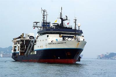
Transit Cruise
Doug Baird · UAF
Dec 22, 2025 – Jan 8, 2026 · 17 d
Doug Baird · UAF
Dec 22, 2025 – Jan 8, 2026 · 17 d
Kilo Moana · UH
angelicque white · UH
Systematic long-term (greater than a few decades in length) time-series observations of aquatic and terrestrial environments have led to a more comprehensive understanding of the natural ecosystem variability and have enabled an assessment of human impacts on ecosystem dynamics. Because of their ability to store and transport large amounts of heat and to absorb carbon dioxide from the atmosphere, the world's oceans play a critical role in modulating environmental conditions for the sustained well-being of both land-based and marine organisms including humans. Despite their recognized scientific and societal importance, long-term records of key ocean processes are rare. In 1988, the Hawaii Ocean Time-series (HOT) program, near Hawaii was established. For over three decades, teams of scientists based at the University of Hawaii have made critical measurements of the 'state of our sea.' These long-term observations have established a baseline against which future states can be compared. The ship-based HOT program complements other diverse ocean observation programs including remote-sensing via satellites, moored buoys, profiling floats, and autonomous underwater vehicles. All HOT program data are publicly available and are frequently used by researchers and policy makers around the world.
Dec 19 – Dec 23, 2025 · 4 d
Station ALOHA (22.75N, 158W)
Atlantic Explorer · BIOS
Nicholas R. Bates · BIOS
One of the longest open-ocean hydrographic stations in the world is maintained at the Hydrostation S site (formerly known as the Panulirus site) located ~25 km southeast of Bermuda in the North Atlantic Ocean. This program of repeat biweekly hydrographic observations began in 1954 (by Hank Stommel) and now, in its seventh decade, has proved to be the catalyst for numerous studies of ocean physics, biological processes and biogeochemistry. Hydrostation S continues to be recognized as one of the most important sustained ocean time–series. The renewal of the Hydrostation S program is proposed herein, extending this invaluable time–series of ocean hydrography to almost 70 years. The upper ocean warming trend has strengthened (about +1.4° C since the 1970's; ~+0.8°C in last decade) with significant salinification (+0.16). Deeper waters such as the Labrador Sea Water has cooled by a few tenths of a degree and freshened with a marked decadal oscillation. The signature of deoxygenation has been observed at Hydrostation S in the upper ocean (about 4 µmoles kg -1 decade -1 decrease in dissolved oxygen) as well as the oxygen minimum zone (~2.5 µmoles kg -1 decade -1 ). Hydrostation S also supports the longest global ocean CO 2 and acidification time-series (from 1983 to present) The major objective of the proposal is to continue Hydrostation S into the eighth decade with numerous questions related to warming and cooling, salinification and freshening, deoxygenation and insights on biogeochemical changes over time. This program constitutes frequent water column sampling of temperature, salinity, and dissolved oxygen (and indirectly, sampling of important ocean carbon time–series) of the North Atlantic subtropical gyre at the Hydrostation S site. Such work is complementary to other sustained observations such as the Bermuda Atlantic Time–series Study (BATS) and Ocean Flux Program (OFP). We propose to carry out a similar sampling format that has been followed for the past 68 years. As for the past ten years, we would continue to conduct two CTD profiles to better capture the deep–water variability while maintaining all the previous discrete depths. The first CTD cast will profile to full ocean depth (3,300–3,500 m) while the second CTD cast will profile to 500 m (to allow for instrumentation not rated for full ocean depth such as a PAR sensor). One indirect objective will be to continue to collaboratively evaluate a BIOS-based glider program with Hydrostation S data as critically important ground truthing data. The existing glider program has challenging issue, and the aim of this effort is to use robust and highly accurate Hydrostation S data to test the capability of emerging technologies over the next five to ten years.
Dec 19 – Dec 20, 2025 · 1 d
Appxoimately 25 nm south east of the island of Bermuda
Jeff Pietro · WHOI
Safely and efficiently deploy Charleston Whale Detection System and turnaround Savannah Whale Detection System
Dec 15 – Dec 17, 2025 · 1 d
Coast of Savannah and Charlston
Brad Seibel · USF
We propose to measure the temperature- and oxygen dependency of aerobic scope and to use a recently derived relationship between metabolic traits to model the corresponding metabolically available habitat for several dominant vertical migrators. In contrast to coastal species, we hypothesize that diel migrators experience unique selective pressures across their depth range and, as a result, aerobic scope is enhanced at high temperature. To test these hypotheses and map their real world implications we need to 1) measure the active and resting metabolic rates of multiple migratory species across a range of temperatures and oxygen levels, 2) compare the biogeography modeled from metabolic traits with the actual distribution of migrators, and 3) determine whether aerobic scope, beyond the proposed benchmark level, influences performance (e.g. survival and recovery from hypoxic stress), which likely influence fitness and biogeography. In conjunction with a novel depth sampling strategy and acoustic and hydrographic measurements, the proposed physiological measurements will provide insight into the energetic constraints and opportunities that influence native and future habitats. We have proposed two cruises, 21 days each, both in Guaymas Basin, Gulf of California.
Dec 14, 2025 – Jan 13, 2026 · 31 d
Guaymas Basin
Hannah Delapp · SIO
Dec 13 – Dec 31, 2025 · 18 d
F.G. Walton Smith · UMIAMI
Lisa Beal · UMIAMI
The UM Keymester cruise aboard RV Walton Smith allows junior and senior level undergraduates majoring in Oceanography to design and execute their own day-long experiment to find and measure the Gulf Stream front using shipboard and towed instrumentation.
Dec 11, 2025 · 1 d
Miami
Atlantic Explorer · BIOS
Nicholas R. Bates · BIOS
One of the longest open-ocean hydrographic stations in the world is maintained at the Hydrostation S site (formerly known as the Panulirus site) located ~25 km southeast of Bermuda in the North Atlantic Ocean. This program of repeat biweekly hydrographic observations began in 1954 (by Hank Stommel) and now, in its seventh decade, has proved to be the catalyst for numerous studies of ocean physics, biological processes and biogeochemistry. Hydrostation S continues to be recognized as one of the most important sustained ocean time–series. The renewal of the Hydrostation S program is proposed herein, extending this invaluable time–series of ocean hydrography to almost 70 years. The upper ocean warming trend has strengthened (about +1.4° C since the 1970's; ~+0.8°C in last decade) with significant salinification (+0.16). Deeper waters such as the Labrador Sea Water has cooled by a few tenths of a degree and freshened with a marked decadal oscillation. The signature of deoxygenation has been observed at Hydrostation S in the upper ocean (about 4 µmoles kg -1 decade -1 decrease in dissolved oxygen) as well as the oxygen minimum zone (~2.5 µmoles kg -1 decade -1 ). Hydrostation S also supports the longest global ocean CO 2 and acidification time-series (from 1983 to present) The major objective of the proposal is to continue Hydrostation S into the eighth decade with numerous questions related to warming and cooling, salinification and freshening, deoxygenation and insights on biogeochemical changes over time. This program constitutes frequent water column sampling of temperature, salinity, and dissolved oxygen (and indirectly, sampling of important ocean carbon time–series) of the North Atlantic subtropical gyre at the Hydrostation S site. Such work is complementary to other sustained observations such as the Bermuda Atlantic Time–series Study (BATS) and Ocean Flux Program (OFP). We propose to carry out a similar sampling format that has been followed for the past 68 years. As for the past ten years, we would continue to conduct two CTD profiles to better capture the deep–water variability while maintaining all the previous discrete depths. The first CTD cast will profile to full ocean depth (3,300–3,500 m) while the second CTD cast will profile to 500 m (to allow for instrumentation not rated for full ocean depth such as a PAR sensor). One indirect objective will be to continue to collaboratively evaluate a BIOS-based glider program with Hydrostation S data as critically important ground truthing data. The existing glider program has challenging issue, and the aim of this effort is to use robust and highly accurate Hydrostation S data to test the capability of emerging technologies over the next five to ten years.
Dec 10 – Dec 14, 2025 · 4 d
Appxoimately 25 nm south east of the island of Bermuda
Atlantic Explorer · BIOS
Nicholas R. Bates · BIOS
Long-term observations over several decades are a powerful tool for investigating ocean physics, biology, and chemistry, and the response of the oceans to environmental change. The Bermuda Atlantic Time-Series Study, known as BATS, has been running continuously since 1988. The research goals of the BATS program are: (1) to improve our understanding of the time-varying components of the ocean carbon cycle and the cycles of related nutrient elements such as nitrogen, phosphorus, and silicon; and, (2) to identify the relevant physical, chemical and ecosystem properties responsible for this variability. In addition, the BATS program has strong and diverse broader impacts, contributing to the field of ocean sciences by providing high quality ocean observations and data for seagoing scientists and modelers, and a framework through which researchers can conceive and test hypotheses. This award will support the operations of the BATS program for five more years. The primary BATS research themes are as follows: (1) Quantify the role of ocean-atmosphere coupling and climate variability on air-sea exchange of CO2, and carbon export to the ocean interior; (2) Document trends and the controls on the interannual to decadal scale variability in carbon and nutrient cycles to their coupling in the surface and deep ocean via the Redfield Ratio paradigm; (3) Quantify the response of planktonic community structure and function, and impact on biogeochemical cycles to variability in surface fluxes and dynamical processes; (4) Facilitate development, calibration and validation of next generation oceanographic sensors, tools and technologies; and, (5) Generate a dataset that can be utilized by empiricists, modelers and students. This research integrates ocean physics, chemistry and biology into a framework for understanding oceanic processes and ocean change in the North Atlantic subtropical gyre. The existing 29 years of BATS data provide robust constraints on seasonal and interannual variability, the response of the Sargasso Sea ecosystem to natural climate variability, and signal detection of potential ocean changes. This project would extend the BATS program through years 31-35 to address a series of ten interlinked questions through integrated research approaches and a multitude of collaborative efforts. In addition to the themes above, and embedded into the ten questions and approaches, the BATS team will focus on, for example, coupling of particle production and biogeochemistry; revisiting the complexities of the biological carbon pump; oxygen decline; and changes in the hydrography, physics, ocean carbon cycle and biogeochemistry of the Sargasso Sea. The highest quality data observation and collection will be maintained and used to address these questions. Importantly, a wide range of collaborations at the BATS site, spanning the physical and biogeochemical disciplines, will aid these broad goals. Strong links to community stakeholders, and close collaboration (including methods intercomparisons and personnel exchanges) with the Hawaii Ocean Time-series are proposed. This work will extend the research findings of the project into educational and training opportunities within and beyond the oceanographic community, including training and mentorship of both undergraduate and graduate students.
Dec 10 – Dec 14, 2025 · 4 d
Appxoimately 25 nm south east of the island of Bermuda
Gabi Laske · SIO
TeSSA is a three-year project to design, construct and test a long-term Telemetered Seafloor Seismic Array (TeSSA) of five seafloor nodes (SFNs) each comprising a very-broadband ocean bottom seismometer (OBS) and a differential pressure gauge. Each SFN will be equipped with an acoustic micromodem. The array is linked through a wave glider that facilitates a Surface Communications Gateway (SCG) with shore-side mission control at Scripps Institution of Oceanography (SIO) via acoustic and satellite services. The TeSSA-cruise 2R is a recovery cruise for the wave glider and two OBSs that were deployed on cruise TeSSA-cruise 2D. The test should last about two weeks so this cruise should be two week after cruise TeSSA-cruise 2D.
Dec 9 – Dec 10, 2025 · 1 d
off-shore San Diego about 32.89N 117.74W
Kilo Moana · UH
Glenn Carter · Hawaii
Undergraduate and graduate students will be exposed to a diversity of at-sea scientific operations and data, including wire lowered (CTD), towed (nekton net), acoustic (Shipboard ADCP, multibeam bathymetry), and free-falling (Hadal Water Column Profiler, baited bottom trap) instrumentation. This suite of instruments will allow students to experience physical, chemical, and biological oceanographic disciplines at sea, and reinforce concepts introduced in their oceanography classes. Sailing aboard the R/V Kilo Moana provides undergraduate students with a unique opportunity to explore non-academic paths to working in oceanography such as ship crew, marine technicians and engineers, as well as the opportunity to get to know graduate students and faculty in an informal setting. Further data from this cruise will be available for GES student theses (a degree requirement).
Dec 5 – Dec 7, 2025 · 2 d
Waianae Coast, Ohau
F.G. Walton Smith · UMIAMI
Ryan Smith · AOML
Researchers from NOAA's Atlantic Oceanographic and Meteorological Laboratory (AOML) in Miami, FL, conduct regular bimonthly hydrographic surveys at 27N in the Florida Straits to monitor the transport and water-mass properties of the Florida Current. The Florida Current is part of the Gulf Stream system, which is the upper limb of the western boundary current system in the North Atlantic Ocean. These cruises are a part of the laboratory’s long-running Western Boundary Time Series (WBTS) project and directly measure the Florida Current at nine locations across the Straits of Florida at 27N, between Jupiter, Florida, and the Little Bahama Bank in the Bahamas. WBTS 27N hydrographic sections, conducted bimonthly throughout the year, are critical to improving our understanding of the North Atlantic Subtropical Gyre circulation and the Atlantic Meridional Overturning Circulation (AMOC). Importantly, data collected during these cruises and others are also used to calibrate the 27N submarine cable system which publicly provides daily transport estimates of the Florida Current . The AMOC is a significant factor in climate change, oceanic carbon sequestration, and sustainable fisheries.
Dec 4 – Dec 5, 2025 · 1 d
Straits of Florida
Atlantic Explorer · BIOS
Nicholas R. Bates · BIOS
One of the longest open-ocean hydrographic stations in the world is maintained at the Hydrostation S site (formerly known as the Panulirus site) located ~25 km southeast of Bermuda in the North Atlantic Ocean. This program of repeat biweekly hydrographic observations began in 1954 (by Hank Stommel) and now, in its seventh decade, has proved to be the catalyst for numerous studies of ocean physics, biological processes and biogeochemistry. Hydrostation S continues to be recognized as one of the most important sustained ocean time–series. The renewal of the Hydrostation S program is proposed herein, extending this invaluable time–series of ocean hydrography to almost 70 years. The upper ocean warming trend has strengthened (about +1.4° C since the 1970's; ~+0.8°C in last decade) with significant salinification (+0.16). Deeper waters such as the Labrador Sea Water has cooled by a few tenths of a degree and freshened with a marked decadal oscillation. The signature of deoxygenation has been observed at Hydrostation S in the upper ocean (about 4 µmoles kg -1 decade -1 decrease in dissolved oxygen) as well as the oxygen minimum zone (~2.5 µmoles kg -1 decade -1 ). Hydrostation S also supports the longest global ocean CO 2 and acidification time-series (from 1983 to present) The major objective of the proposal is to continue Hydrostation S into the eighth decade with numerous questions related to warming and cooling, salinification and freshening, deoxygenation and insights on biogeochemical changes over time. This program constitutes frequent water column sampling of temperature, salinity, and dissolved oxygen (and indirectly, sampling of important ocean carbon time–series) of the North Atlantic subtropical gyre at the Hydrostation S site. Such work is complementary to other sustained observations such as the Bermuda Atlantic Time–series Study (BATS) and Ocean Flux Program (OFP). We propose to carry out a similar sampling format that has been followed for the past 68 years. As for the past ten years, we would continue to conduct two CTD profiles to better capture the deep–water variability while maintaining all the previous discrete depths. The first CTD cast will profile to full ocean depth (3,300–3,500 m) while the second CTD cast will profile to 500 m (to allow for instrumentation not rated for full ocean depth such as a PAR sensor). One indirect objective will be to continue to collaboratively evaluate a BIOS-based glider program with Hydrostation S data as critically important ground truthing data. The existing glider program has challenging issue, and the aim of this effort is to use robust and highly accurate Hydrostation S data to test the capability of emerging technologies over the next five to ten years.
Dec 3, 2025 · 1 d
Appxoimately 25 nm south east of the island of Bermuda
Glenn Spinelli · NMT
This study will collect temperature measurements in seafloor sediments offshore southern Mexico, and map the distribution of those sediments, to understand the controls on temperatures in the system and improve estimates of subduction zone temperatures. The results of this research have direct societal benefit, by informing earthquake hazard estimates. In addition, the proposed project will enhance education at New Mexico Tech and UNM; both are Hispanic-serving institutions. Two graduate students will be trained in geophysics and hydrogeology. Results of the project will be incorporated into using data in the classroom efforts, improving hands-on experience in undergraduate courses.
Dec 2 – Dec 26, 2025 · 24 d
Offshore southern Mexico. - Eastern Pacific - Guerrero Gap off of the Guerrero state in Mexico - subduction zone offshore Mexico near Acapulco city.
Robert Kamphaus · UW
Instrument verification cruise to test out all the newly installed and relocated science systems on R/V Thomas G. Thompson following an intermediate drydock period in Aug-Oct 2025.
Pelican · LUMCON
SHARON HERZKA · UT Austin
The University of Texas Marine Science Institute’s Texas Gulf Coast Research Center (TGCRC) launches a collaborative interdisciplinary project to understand how the exchange between estuarine and coastal waters controls fisheries recruitment and production, biodiversity, trophic linkages, carbon and nitrogen sources and cycling, geomorphology, and the environmental impacts of contaminants. The project focuses on Aransas Pass on the Texas Coastal Bend and includes four themes. (1) Estuarine and ocean exchange. Influence of freshwater inflows and circulation on the transport of organisms, sediments, and key environmental variables over two temporal scales: the reconstruction of how anthropogenic activities since the late 19 th century have affected the salinities, sedimentation rates, carbon burial rates, and communities of dominant organisms, and present-day exchange processes. (2) Biogeochemistry. Ecosystem metabolism, carbon and nitrogen sources, and cycling. (3) Higher trophic level responses. Influence on secondary production, fish physiological responses, faunal diversity, biological connectivity, habitats, trophic linkages, and fisheries production. (4) Contaminants –Environmental impact of anthropogenic pollutants on ecologically and economically important marine species. The data will be integrated through circulation and ecosystem-level numerical models, resulting in a comprehensive understanding of the historical and present-day coastal-estuarine exchange in arid regions with limited freshwater inflow and a small tidal range.
Nov 30 – Dec 16, 2025 · 16 d
Inner Texas Shelf close to the Aransas Pass
Magdalena Andres · WHOI
This NOPP Global Internal Wave (GIW) Study aims to deploy Internal Wave Resolving (IWR) Arrays globally to analyze the generation, propagation and dissipation of internal waves in the ocean using a combination of high vertical-resolution moorings and bottom mounted echo sounders to determine wave modal structures, speed, and direction of internal wave propagation. These internal-wave resolving (IWR) arrays consist of current- and pressure-sensor-equipped inverted echo sounders (CPIESs), current-sensor-equipped PIESs (CPIESs), and a densely instrumented, full-depth mooring. The observations are being used to enable seamless, skillful modeling and forecasts of these internal waves between the deep ocean and the shore. In fall 2024, a partial IWR Array comprising 6 CPIESs was deployed on a cruise of opportunity around one of the tall moorings deployed by the Mixing belOw Tropical Instability waVEs (MOTIVE) team in the Equatorial North Pacific. These CPIESs will be recovered as part of the MOTIVE recovery cruise.
Caitlin Whalen · UW
This project supports an oceanographic field campaign in the tropical Pacific to make high temporal and spatial resolution measurements from moorings and ship of the oceanic velocity, density, and microstructure. Observations will be made of westward propagating oceanic fronts in the presence of Tropical Instability Waves (TIW) to better understand their influence on mixing and modulation of oceanic internal waves. The proposed work has important implications for understanding the El Nino Southern Oscillation (ENSO) and the role of the tropical oceans in climate. Education and outreach for this project will include mentoring a graduate student and postdoc, science presentations at local high schools, mentorship for Research Experience for Undergraduates (REU) interns, and participation in the Ocean Discovery Institute homework assistance program. This project addresses the dynamic processes that govern the observed modulation of internal waves, and turbulent mixing, by TIWs in the equatorial Pacific and the potential effects on heat regulation and ENSO predictability. Mechanisms to be studied include radiation of downward propagating internal waves from TIWs, modulation of the internal wave field by TIWs, and the fate of the internal waves in the presence of critical layers. The observational campaign will employ moorings, ship-mounted acoustics, ship-based profiling systems including a rapid profiling CTD (fastCTD) and a turbulence profiler (Epsilometer), and three autonomous drifting wave-powered profilers (WireWalkers). Three moorings will be deployed for a year north of the operational 140°W Tropical Atmosphere Ocean (TAO) mooring to target the seasonal cycle in the TIW modulation of internal waves and mixing.
Atlantic Explorer · BIOS
Nicholas R. Bates · BIOS
Long-term observations over several decades are a powerful tool for investigating ocean physics, biology, and chemistry, and the response of the oceans to environmental change. The Bermuda Atlantic Time-Series Study, known as BATS, has been running continuously since 1988. The research goals of the BATS program are: (1) to improve our understanding of the time-varying components of the ocean carbon cycle and the cycles of related nutrient elements such as nitrogen, phosphorus, and silicon; and, (2) to identify the relevant physical, chemical and ecosystem properties responsible for this variability. In addition, the BATS program has strong and diverse broader impacts, contributing to the field of ocean sciences by providing high quality ocean observations and data for seagoing scientists and modelers, and a framework through which researchers can conceive and test hypotheses. This award will support the operations of the BATS program for five more years. The primary BATS research themes are as follows: (1) Quantify the role of ocean-atmosphere coupling and climate variability on air-sea exchange of CO2, and carbon export to the ocean interior; (2) Document trends and the controls on the interannual to decadal scale variability in carbon and nutrient cycles to their coupling in the surface and deep ocean via the Redfield Ratio paradigm; (3) Quantify the response of planktonic community structure and function, and impact on biogeochemical cycles to variability in surface fluxes and dynamical processes; (4) Facilitate development, calibration and validation of next generation oceanographic sensors, tools and technologies; and, (5) Generate a dataset that can be utilized by empiricists, modelers and students. This research integrates ocean physics, chemistry and biology into a framework for understanding oceanic processes and ocean change in the North Atlantic subtropical gyre. The existing 29 years of BATS data provide robust constraints on seasonal and interannual variability, the response of the Sargasso Sea ecosystem to natural climate variability, and signal detection of potential ocean changes. This project would extend the BATS program through years 31-35 to address a series of ten interlinked questions through integrated research approaches and a multitude of collaborative efforts. In addition to the themes above, and embedded into the ten questions and approaches, the BATS team will focus on, for example, coupling of particle production and biogeochemistry; revisiting the complexities of the biological carbon pump; oxygen decline; and changes in the hydrography, physics, ocean carbon cycle and biogeochemistry of the Sargasso Sea. The highest quality data observation and collection will be maintained and used to address these questions. Importantly, a wide range of collaborations at the BATS site, spanning the physical and biogeochemical disciplines, will aid these broad goals. Strong links to community stakeholders, and close collaboration (including methods intercomparisons and personnel exchanges) with the Hawaii Ocean Time-series are proposed. This work will extend the research findings of the project into educational and training opportunities within and beyond the oceanographic community, including training and mentorship of both undergraduate and graduate students.
Nov 25 – Nov 27, 2025 · 2 d
Atlantic
Kilo Moana · UH
angelicque white · UH
Systematic long-term (greater than a few decades in length) time-series observations of aquatic and terrestrial environments have led to a more comprehensive understanding of the natural ecosystem variability and have enabled an assessment of human impacts on ecosystem dynamics. Because of their ability to store and transport large amounts of heat and to absorb carbon dioxide from the atmosphere, the world's oceans play a critical role in modulating environmental conditions for the sustained well-being of both land-based and marine organisms including humans. Despite their recognized scientific and societal importance, long-term records of key ocean processes are rare. In 1988, the Hawaii Ocean Time-series (HOT) program, near Hawaii was established. For over three decades, teams of scientists based at the University of Hawaii have made critical measurements of the 'state of our sea.' These long-term observations have established a baseline against which future states can be compared. The ship-based HOT program complements other diverse ocean observation programs including remote-sensing via satellites, moored buoys, profiling floats, and autonomous underwater vehicles. All HOT program data are publicly available and are frequently used by researchers and policy makers around the world.
Nov 20 – Nov 24, 2025 · 4 d
Station ALOHA (22.75N, 158W)
Hunter Edwards · SIO
Ocean islands, such as Cape Verde, erupt a specific type of basalt termed ocean island basalt, or OIB. These are relatively enriched melts from the mantle, compared with mid-ocean ridge basalts. It has been shown that OIB provide an exclusive look into the composition of deep mantle source reservoirs (Hofmann, 1997; Stracke, 2012). Compared with volcanic rocks that form at convergent plate boundaries, OIB also undergo relatively less modification, such as crustal assimilation, and are widely considered direct mantle ‘probes’(e.g., Weis et al., 2011; Jackson et al., 2018; Doucet et al., 2020; Day et al., 2022). Overall, Cape Verde seamounts are under sampled, and the collection of rock and glass samples, in addition to bathymetric mapping would improve our understanding of this OIB province. We will target samples for 40Ar-39Ar age dating and geochemistry (major and trace elements, Sr-Nd-Pb-Os isotopes, all done at SIO) to unravel the geochemical disparity between the northern and southern islands, provide insight into the contrasting composition of Cadamosto Seamount, and resolve the mantle reservoir(s) that Cape Verde is sourcing. This work will aid in understanding past eruption styles in Cape Verde, including both subaerial and submarine, which pose hazards to human health and safety.
Nov 19 – Dec 2, 2025 · 13 d
Cape Verde
Pelican · LUMCON
Eric Aronchick · WHOI
Perform seasonal, full water column CTD sampling + DO + PSD analysis and water collection, at a single offshore location with a depth of approximately 6,500 feet. A total of four quarterly cruises will be undertaken between August 2025 and May 2026. Onboard lab analysis of water samples will be measured and recorded. Water samples will be collected and brought back to shore for more intensive lab testing and chemical analysis.
Nov 18 – Nov 20, 2025 · 2 d
US GoM, Approx. 130 nm SE of Cocodrie, LA
Sienna Thomas · SIO
Launch and recovery of a 3000m rated AUV.
Nov 17 – Nov 20, 2025 · 3 d
SOCAL
Katherine Ackerman · UH
Sea salt aerosols are particles that are formed from blowing winds and breaking waves over the ocean surface. These particles can act as the building blocks for cloud droplets and eventually precipitation. Very large particles, known as giant sea salt aerosols (GSSA) have been historically difficult to observe because most instrumentation has been designed for smaller particles. There remains considerable uncertainty regarding the production and vertical mixing of GSSA particles within the lowest part of the atmosphere above the ocean?s surface. This study will make measurements of GSSA using a specialized instrument and combine that with numerical modeling to address questions about how these particles move through the atmosphere. This award is for observational and modeling research that will address a critical gap in aerosol research relating to giant sea salt aerosol production and distribution. The research plan consists of a three-pronged approach. The researcher will use the mini-Giant Nuclei Impactor to make observations of GSSA during research cruises from Hawai'i. These data will be analyzed to construct a distribution of GSSA from the turbulent wave layer through the mixed layer of the atmosphere.
Nov 15 – Nov 24, 2025 · 10 d
Drew Lucas · SIO
Ocean/atmosphere coupling influences atmospheric river (AR) track, timing, and intensity. Uncertainty in ocean conditions both far upstream and just prior to landfall – as well as inadequacies in the parameterizations of air-sea exchange in forecast models – can yield significant forecast uncertainty even on short time horizons (1-3 d). Similarly, it is not yet clear the extent to which ocean/atmosphere interactions impact the development of extreme AR events, for example from “stalling” fronts (e.g. Zou et al. 2023), or those that occur during conditions of anomalous ocean heat content (e.g. El Nino; Bartusek et al. 2021). Key to improving our understanding of the coupled ocean/atmosphere evolution during the formation and passage of an atmospheric river is the collection of in situ research-grade air/sea fluxes and ocean boundary layer response in high resolution and in real time. Under past ONR funding, we have collaboratively developed a system that provides this information at the sea-surface and continuously across the ocean boundary layer to depths of several hundred meters, utilizing a unique ocean wave-powered profiler and a relatively low-cost, easy-to-deploy buoy.
Nov 15 – Nov 24, 2025 · 10 d
Gabi Laske · SIO
TeSSA is a three-year project to design, construct and test a long-term Telemetered Seafloor Seismic Array (TeSSA) of five seafloor nodes (SFNs) each comprising a very-broadband ocean bottom seismometer (OBS) and a differential pressure gauge. Each SFN will be equipped with an acoustic micromodem. The array is linked through a wave glider that facilitates a Surface Communications Gateway (SCG) with shore-side mission control at Scripps Institution of Oceanography (SIO) via acoustic and satellite services. The TeSSA-cruise 2D is a deployment cruise for the wave glider and two OBSs. The test should last about two weeks after which both wave glider and OBS will be recovered on the recovery cruise TeSSA-cruise 2R.
Nov 13 – Nov 14, 2025 · 1 d
off-shore San Diego about 32.89N 117.74W
F.G. Walton Smith · UMIAMI
Ryan Smith · AOML
Researchers from NOAA's Atlantic Oceanographic and Meteorological Laboratory (AOML) in Miami, FL, conduct regular bimonthly hydrographic surveys at 27N in the Florida Straits to monitor the transport and water-mass properties of the Florida Current. The Florida Current is part of the Gulf Stream system, which is the upper limb of the western boundary current system in the North Atlantic Ocean. These cruises are a part of the laboratory’s long-running Western Boundary Time Series (WBTS) project and directly measure the Florida Current at nine locations across the Straits of Florida at 27N, between Jupiter, Florida, and the Little Bahama Bank in the Bahamas. WBTS 27N hydrographic sections, conducted bimonthly throughout the year, are critical to improving our understanding of the North Atlantic Subtropical Gyre circulation and the Atlantic Meridional Overturning Circulation (AMOC). Importantly, data collected during these cruises and others are also used to calibrate the 27N submarine cable system which publicly provides daily transport estimates of the Florida Current . The AMOC is a significant factor in climate change, oceanic carbon sequestration, and sustainable fisheries.
Nov 13 – Nov 15, 2025 · 2 d
Straits of Florida