VesselConnect

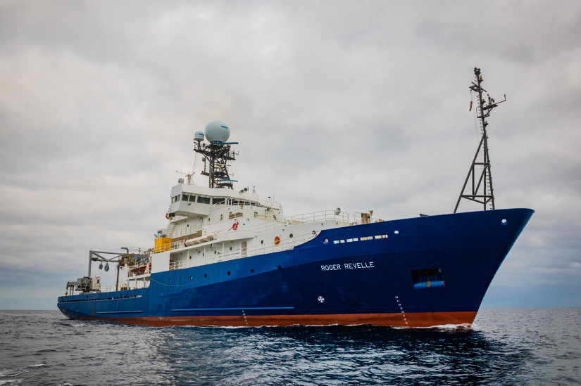
Roger Revelle

UNOLS

Roger Revelle photo 1USAphoto: Scripps Institution of Oceanography, UC San Diego

Oceanography

Loading map…

Oct 2025 – Oct 2026 · 18 port calls · 187 at-sea periods

Operating area: Global

37

Research bunks

83 m

Length

11 kn

Cruise speed

52

Endurance

15000 nm

Range

1996

Year built

22

Crew

Projects

16+ past · 11 upcoming

Completed

UFO ( 2nd cruise)

Robert Pickart · WHOI

This project will maintain a high-resolution mooring array to quantitatively measure, for the first time, what appears to be the main conduit of dense water feeding the Faroe Bank Channel overflow. Accompanying shipboard surveys will trace the flow upstream to its source region(s), and also document its downstream evolution to where it overflows in the Faroe Bank Channel. We will augment the observations with modeling and simple theory to provide dynamical context. The work is part of a larger international program to address the pathways and mechanisms by which dense water is supplied to the eastern Greenland-Scotland Ridge, through coordinated observations and modeling. Researchers from seven institutions comprise the team, each bringing considerable resources and expertise. Together, this will fundamentally advance our understanding of this important component of the AMOC. The name of the collaborative program is “Upstream Pathways of the Faroe Overflow” (UFO).

Aug 15 – Sep 18, 2025 · 34 d

Nordic Seas - Extending from eastern Iceland to western Norway in the general vicinity of the Greenland-Scotland Ridge

Completed

Transit Cruise

Hannah Delapp · SIO

Sep 21 – Oct 3, 2025 · 12 d

Completed

Chain Cruise 2

Jessica Warren · UDel

This collaborative project is to explore the structure, seismicity, rheology, and magmatism within the slow-slipping Chain Transform Fault in the equatorial Atlantic. The formation of localized zones of deformation is a key attribute of plate tectonics. Oceanic transform faults are ideal laboratories for studying the mechanisms of localized deformation due to their relatively uniform composition and predictable motion. Many aspects of strain accommodation remain poorly understood, including (1) the extent to which cracking and seawater-driven reactions cause fault weakening deep into the fault, (2) the role of serpentine and other phyllosilicates in accommodating aseismic creep, and (3) the importance of melt infiltration and weakening within the fault zone. While existing samples of transform faults provide constraints on strain weakening mechanisms, very little sampling has been done in concert with the collection of structural and seismicity data to directly link fault behavior to rheology. An interdisciplinary field program to study the structure, composition, and seismicity of the Chain Transform Fault will be conducted through two research cruises. The first cruise, aboard the R/V Langseth, will collect multi-channel seismics to image sub-surface fault structures and the extent of magmatism in the fault domain. An ocean bottom seismometer array will be deployed during the cruise to determine the depth extent of microseismicity and the relationship between fault structures and seismicity. The second cruise will occur one year later to recover the OBS array. This cruise will dredge the fault zone to determine the composition and rheology of the fault and conduct surveys using AUV Sentry to identify the surface expression of the fault.

Oct 11 – Nov 12, 2025 · 32 d

Equatorial Atlantic at 1.5S and 15W.

Completed

RR25 Edwards

Hunter Edwards · SIO

Ocean islands, such as Cape Verde, erupt a specific type of basalt termed ocean island basalt, or OIB. These are relatively enriched melts from the mantle, compared with mid-ocean ridge basalts. It has been shown that OIB provide an exclusive look into the composition of deep mantle source reservoirs (Hofmann, 1997; Stracke, 2012). Compared with volcanic rocks that form at convergent plate boundaries, OIB also undergo relatively less modification, such as crustal assimilation, and are widely considered direct mantle ‘probes’(e.g., Weis et al., 2011; Jackson et al., 2018; Doucet et al., 2020; Day et al., 2022). Overall, Cape Verde seamounts are under sampled, and the collection of rock and glass samples, in addition to bathymetric mapping would improve our understanding of this OIB province. We will target samples for 40Ar-39Ar age dating and geochemistry (major and trace elements, Sr-Nd-Pb-Os isotopes, all done at SIO) to unravel the geochemical disparity between the northern and southern islands, provide insight into the contrasting composition of Cadamosto Seamount, and resolve the mantle reservoir(s) that Cape Verde is sourcing. This work will aid in understanding past eruption styles in Cape Verde, including both subaerial and submarine, which pose hazards to human health and safety.

Nov 19 – Dec 2, 2025 · 13 d

Cape Verde

Completed

Transit Cruise

Hannah Delapp · SIO

Dec 13 – Dec 31, 2025 · 18 d

Completed

MWMS_LTER

Brice Loose · URI

This project will build a new instrument to measure meltwater from glaciers in the ocean. The causes and impacts of melting glaciers are a challenge to observe and predict, because they unfold in complex and hard to reach places: beneath miles of ice, under floating ice shelves, and during the coldest times of the year. The objective of this instrument is to increase oceanographer's capacity to measure and map glacier melt in the ocean by 300-400%, while reducing costs and providing near real-time results. This increase in measurement capacity will permit comparison of regional and seasonal changes in the glacier melt from the ice-covered land masses of Antarctica and Greenland. The instrument will be field validated in Rhode Island coastal waters, and then it will be used to measure glacier melt near the US Palmer Station on the Antarctic Peninsula. The partnership between the University of Rhode Island and SRI international presents an important public-private partnership that will encourage the use of private-sector technology for open access research, and recruit the future workforce in environmental sensing technology by employing undergraduate ocean engineers and supporting a graduate student.

Jan 10 – Feb 28, 2026 · 49 d

Western Antarctic Peninsula

Sails with 1 other project

Completed

PAL LTER 2026

oscar schofield · Rutgers

The Palmer Station Antarctica Long-Term Ecological Research (PAL LTER) program seeks to understand how sea ice-influenced marine ecosystem productivity and structure is driven by local, regional, and remote physical forcing. Our current research builds on three decades of long-term research along the western side of the Antarctic Peninsula (WAP) and is focused on developing a predictive framework of the observed ecosystem changes in response to disturbances spanning long-term, sub-decadal, and higher frequency “pulses”. PAL has been documenting how these disturbances are altering food-web composition and ecological interactions across time and space scales. The ecological dynamics in the WAP differ from other marine pelagic systems given the importance of glacial/sea ice on marine food webs by modulating solar inputs to the ocean, inhibiting wind mixing, altering the freshwater balance and ocean stability, and providing a physical substrate for organisms. Current warming suggests the system may transitioning from polar sea dominated to a warmer maritime pelagic system. We organize our research efforts under three focused themes: A. Drivers of disturbance across time and space scales: ecological and latitudinal response, B. Vertical and alongshore connectivity as drivers of ecological change on local to regional scales, and C. Changing food webs and carbon cycling.

Jan 10 – Feb 28, 2026 · 49 d

Western Antarctic Peninsula

Sails with 1 other project

Completed

GO-SHIP A16S

Leticia Barbero Munoz · UMIAMI

This cruise is part of the decadal re-occupation of select hydrographic transects in the Atlantic Ocean to determine natural and man-made changes in chemical and physical properties in the ocean under auspices of the international program Global Ocean Ship-based Hydrographic Investigations Program GO-SHIP (www.go-ship.org). The focus of this particular cruise is to determine the changes in anthropogenic CO2, distributions and fluxes in the South Atlantic ocean since the last occupation in 2014 as part of the GO-SHIP program. Decadal variations of CO2 tracers, oxygen, and temperature distributions are strongly influenced by climate change and natural processes. This research is co-sponsored by the USA agencies NOAA and NSF. Clearance to conduct research in Argentinian and UK EEZ waters will be requested.

Mar 10 – May 1, 2026 · 52 d

South Atlantic

Completed

PB&Jb-3

Kurt Polzin · WHOI

This cruise will deploy a moored sensor network with the goal of understanding the coupling between internal waves and bottom boundary layers over steep and rough topography. The sensor network will be deployed in the Brazil Basin to quantify near boundary flow distortions due to finite amplitude topography, near boundary internal wave breaking, and momentum and buoyancy fluxes in both turbulent and internal wavebands (i.e. drag and mixing). Extant data obtained as part of a Tracer Release Experiment in the same domain and data from the Global Drifter Program will be used to create a regional statistical characterization of the oceanic internal wavefield in the Sub-Tropical South Atlantic. This characterization will be compared to a hierarchy of five models: an operational forecast model (HYCOM), O(1-3) km horizontal resolution ROMS-CROCO, nonhydrostatic ROMS-CROCO ’mountain scale’ simulations with 50 m resolution and 1:1 grid aspect ratio, realistic Large Eddy Simulations (LES), and a quasi-analytic spectral representation of the internal wave energy spectrum. The proposed work is synergistic: the field characterization represents ground truth, the quasi-analytic model is constrained by those highly resolved data and can be modified to critique how a numerical model’s truncation of topographic variability impacts the mid-water column internal wavefield, the global models assist assessment of non-local generation and propagation not represented in the quasi-analytic model, quantification of nonlinear wave-wave interactions in the ’mountain scale’ simulations provides insight into theoretical treatments. Observed data and LES permit investigation of interactions between boundary layer dynamics, wave generation and the forward cascade to turbulence.

May 9 – Jun 10, 2026 · 31 d

Brazil Basin, 20S, 18W

Completed

Tehuantepec MT

Steven Constable · SIO

The Gulf of Tehuantepec is considered a "seismic gap", in that there have been no recorded large thrust earthquakes associated with the tectonic plates slipping past each other. There are two possible reasons for this. The first is that the rocks of the Tehuantepec Ridge, which is being subducted with the Cocos plate, may be releasing water that lubricates the fault zone, allowing the plates to slowly slide past each other without producing large earthquakes. The second is that the topography of the ridge is mechanically locking the two plates together, in which case a very large earthquake is inevitable when the stress finally builds up to breaking point. Do the people of Mexico plan for a strong, damaging earthquake that will likely create a large tsunami, or rest assured that the plate is slipping benignly? This project will answer this question with an amphibious magnetotelluric (MT) sounding survey sensitive to the presence of water deep in the subduction zone. Land MT sites have already been collected. This ship time application will support the offshore component.

Jun 12 – Jun 30, 2026 · 18 d

Gulf of Tehuantepec

Sails with 1 other project

Completed

Low Cost GNSS-A 2026

Surui Xie · Houston

Seafloor geodesy holds the key to providing near-field observations for an improved understanding of offshore earthquakes and many other hazards. Among all major seafloor geodetic techniques, GNSS-A is the preferred technique for long-term monitoring of seafloor velocities, which uses sea surface vessels positioned by the Global Navigation Satellite System (GNSS) to acoustically interrogate seafloor transponders (positioning beacons) for seafloor positioning. However, conventional GNSS-A surveys are extremely expensive due to the high financial cost of seafloor instruments, limiting the number of observational sites. This project develops novel, low-cost GNSS-A methods to expand the coverage of seafloor geodesy. To test the new designs, three GNSS-A sites will be deployed at water depths of about 85, 250, and 570 m offshore Oregon in the proximity of several cabled ocean profilers, and one GNSS-A site will be deployed at about 1100 m water depth in the San Diego Trough offshore San Diego, CA.

Jul 26 – Aug 3, 2026 · 8 d

Offshore California and Oregon

Sails with 1 other project

Completed

Cascadia GNSS-A 2026

Mark Zumberge · SIO

Deformation of the seafloor is an important tectonic process, which can best be studied with marine geodetic techniques. The GNSS-Acoustic method is the technique chosen by a community workshop to investigate the following processes in Cascadia and Alaska: 1. Along-strike changes in coupling and relation to onshore deformation. A strong and widely spaced geodetic backbone offshore of existing on-land geodetic infrastructure, in regions not constrained by land stations could serve as the greatest return on investment for scientific and hazards understanding of megathrust subduction behavior. 2. Near-trench coupling and relation to tsunami earthquake(s) and down-dip behavior. While Alaska is the only of the two locales that has the known occurrence of a damaging tsunami earthquake (characterized by its outsized tsunami wave amplitude for earthquake magnitude) in 1946, it is understood that due to depth restrictions particularly in the 1946 rupture patch, much more of the near-trench environment off Cascadia can be evaluated using current instrument pool transponders. 3. Occurrence of shallow aseismic slip and its relation to earthquakes. The Cascadia subduction zone has clearly observable and large down-dip slow slip events, and an overall large near-trench exposure capable of observation with the geodetic instrument pool. 4. Postseismic time-dependent variations in coupling, including transients, afterslip, viscous relaxation, and recoupling. This was viewed as much more important in Alaska where recent large earthquakes allow for much greater potential for capturing discernable time-dependent variations in coupling behavior.

Jul 26 – Aug 3, 2026 · 8 d

Offshore California and Oregon

Sails with 1 other project

Completed

Ancillary-OOI-RCA-2026 (Multi-Scale Geodesy-6of8)

Bill Chadwick · OSU

Axial Seamount is the most active submarine volcano in the NE Pacific, having erupted in 1998, 2011, and 2015. Because of this, it is an ideal natural laboratory for the long-term study of active processes at a submarine volcano, with periodic perturbations to hydrothermal systems and chemosynthetic biological communities. Long-term monitoring at Axial has built a remarkable time-series of bottom pressure measurements and repeated bathymetric mapping with Autonomous Underwater Vehicles (AUVs) that have documented a cycle of inflation and deflation of ±2-4 meters that has been used to forecast eruptions with increasing accuracy. Since the 2015, Axial has reinflated to >90% of its pre-eruption threshold, but over this same time period the rate of inflation has slowed by an order of magnitude. Consequently, the next eruption is still likely several years away. This project aims to continue this monitoring effort for another 5 years, while improving the techniques, survey designs, and data analysis on several fronts in order to provide improved constraints for modeling the surface deformation to better understand the magma supply and storage system at the volcano. For this project, we request support for field work with ROV Jason and AUV Sentry at Axial Seamount in 2024, 2026, and 2028. Specifically, we propose to: (1) continue the deformation surveys every other year, including both pressure measurements and AUV bathymetric re-surveys over the next 5 years, (2) modify the ROV-based pressure surveys to become more time-efficient by changing reference sites so that we can add more benchmarks in the caldera to better constrain deformation models, (3) add benchmark sites to constrain slip across the caldera faults to increase our understanding of the relationship between deformation and seismicity, and (4) continue OOI Regional Cabled Array (RCA) seafloor-CTD turn-arounds so that salinity sensors will be in place in the caldera during the next eruption to test a hypothesis about co-eruption brine release. These multi-scale monitoring efforts at Axial Seamount will be leveraged by NSF’s infrastructure investment in the OOI-RCA, which provides real-time monitoring data that greatly enhances these efforts. The results from this study will also help to increase our understanding of the shallow magma supply and storage systems at active basaltic volcanoes, the processes that lead to and trigger eruptions, and the pathways that magma takes to the surface during eruptions. This work at Axial Seamount is aimed at helping us better understand eruption processes at volcanoes on land that are more hazardous to people and property.

Aug 9 – Aug 19, 2026 · 9 d

NE Pacific Cascadia Margin and Axial Seamount

Sails with 1 other project

Completed

RCA-VISIONS'26

Deborah Kelley · UW

This cruise is in support of NSF's Ocean Observatories Initiative Regional Cabled Array annual operations and maintenance cruise requiring the ROV Jason . The cruise will focus on turning junction boxes, seafloor instruments and instruments that have failed. Work sites include the Cascadia Margin (80 m - 2900 m water depth) west of Newport Oregon, and the Axial Seamount (1500 m water depth). It is anticipated that cruise activities will be streamed live on the interactiveoceans website and include a contingent of undergraduate students that will participate in the UW at-sea experiential learning VISIONS '26 program.

Aug 9 – Aug 19, 2026 · 9 d

NE Pacific Cascadia Margin and Axial Seamount

Sails with 1 other project

Completed

Transit Cruise

Hannah Delapp · SIO

Sep 11 – Sep 13, 2026 · 2 d

Underway

CA Seabed 3

Kelly Dorgan · DISL

Our interdisciplinary team proposes to test the overarching hypothesis that organic matter input to the deep sea drives biological processes that modify geotechnical and geoacoustic properties of the surface layer of sediments. We will explore the spatial and temporal variability and relationships among these properties in the central California slope. This region experiences seasonal and interannual variability in organic matter deposition to the seabed and spatial variability in the infaunal community. We plan to combine seasonal sampling of geological, geotechnical, geoacoustic, biological, and biogeochemical properties along a spatial gradient with high temporal resolution sampling of the bottom boundary layer and seabed surface. Our results will provide insight on the patterns of seabed properties and the mechanisms driving those patterns and will improve our ability to predict and remotely detect changes in deep sea sediments. In this project we aim to use cutting-edge abyssal direct observing and remote sensing techniques including dense thermistor moorings, dye releases, acoustic reflection and scattering measurements, direct turbulence measuring autonomous floats, direct measurements of sediment load, particle size and settling velocity distribution, and bioacoustics in order to synthesize a complete interdisciplinary picture of the deep sea benthic boundary layer.

Oct 10 – Nov 6, 2026 · 26 d

Central California coast south of Monterey

Scheduled

Transit Cruise

Hannah Delapp · SIO

Nov 12 – Nov 23, 2026 · 10 d

Tentative

Kilauea GNSS-A

Mark Zumberge · SIO

We propose a seafloor geodesy deployment to establish a network of 4 NSF GNSS-Acoustic (GNSS-A) sites, with one absolute pressure gauge (APG) per site, on the submarine south flank of Kīlauea volcano on the Big Island of Hawaii. The GNSS-A sites will be used to measure horizontal displacement rates along a profile running up-dip of the Kīlauea décollement from the near-shore to the toe of the thrust system, while the APGs will measure any transient vertical components. An ROV campaign ambient seawater pressure survey, reoccupying benchmarks previously measured in 2004, will be performed to recover the 20 year cumulative vertical uplift in the same region.

Nov 25 – Dec 5, 2026 · 9 d

South of Hawaii

Sails with 1 other project

Scheduled

ACO

Jim Potemra · UH

The cruise will transit to Station ALOHA, a site 100 km north of the island of Oahu to work on instruments on the seafloor (~5000m depth). The site is the location of the ALOHA Cabled Observatory (ACO), a deep ocean site with cabled-to-shore power and internet, making ACO one of the deepest real-time observatories in the world. The cruise will perform three main tasks: 1) retrieve a faulty sensor package (CTD, fluorometer and pressure gauge, 2) deploy new sensor package, and 3) deploy new camera system. The sensor packages are "plug and play," and an ROV will be used to transport the packages to the site and plug them into the ACO main system. If time allows, the cruise will also recover additional sensors that have been deployed on the sea floor in the vicinity of the ACO as part of a separate project.

Dec 9 – Dec 17, 2026 · 7 d

Central North Pacific (Station ALOHA, 158W, 22N

Scheduled

Transit Cruise

Hannah Delapp · SIO

Jan 10 – Jan 24, 2027 · 15 d

Scheduled

JQZ-Phoenix-MCS-2

Masako Tominaga · UNOLS

This project examines a poorly understood period of geomagnetic field history, the Jurassic Quiet Zone, during which geomagnetic field strength appears to be much lower than normal and the reversal rate much higher than normal. Changes in geomagnetic field behavior are thought to have geodynamic significance, such as indicating heat flux to the mantle from the core, affecting mantle convection. The primary objective of the Phoenix JQZ project is to measure the magnetic anomaly record in the Phoenix lineation set, for comparison to the other two extant marine magnetic records from this period, to better understand the causes and effects of rapid changes in the geomagnetic field. An initial research cruise collected Multi-Channel Seismic (MCS) data over part of the study area to define the top of the magnetic source layer within oceanic crust. This expedition is intended to complete the half of the seismic survey that was missed due to equipment failure, and will be followed directly by another leg to collect multi-scale magnetic data using surface-towed, midwater-towed, and near-seafloor AUV magnetometer deployments. MCS data acquired and processed in advance of the magnetometry leg will enable informed planning for AUV Sentry dives.

Feb 1 – Feb 15, 2027 · 15 d

western equatorial Pacific/Marshall Islands/Micronesia

Scheduled

Transit Cruise

Hannah Delapp · SIO

Feb 22 – Mar 2, 2027 · 8 d

Tentative

Paleoventilation Ages in the Deep Pacific

Lowell Stott · USC

Project Summary Overview Ocean ventilation age estimates for the Last Glacial Maximum (LGM; 19-23 ky BP) present a conundrum. Radiocarbon results from low sedimentation rate sites (<10 cm/kyr) imply deep water ventilation ages were ~800-1000 years older than today, whereas high sedimentation rate sites (>20 cm/kyr) show no substantial difference from today. The contrast is due to either: 1) bioturbation-driven biases in low accumulation rate locations, or 2) the lack of high accumulation rate records from water depths below 3 km. Here we propose to address this problem by acquiring new high-resolution stable isotope and radiocarbon data from high deposition rate sites in the western North Pacific. We propose to obtain sediment cores from the margin of Mindanao in the western Pacific at water depths between 2500 and 3800m. Intellectual Merit Testing whether the ocean sequestered CO 2 would be a major step forward in solving the grand challenge of glacial/interglacial CO 2 cycles. Our research is critical to this effort because previous attempts to evaluate whether ventilation ages were greater during glaciations has been hampered by a lack of high-resolution data sets from the deep (> 3 km) Pacific, which is the largest potential reservoir for the storage of carbon.

Mar 7 – Mar 22, 2027 · 15 d

South Mindanao (Davao Bay) and Eastern Mindanao (Mayo Bay)

Tentative

Common Era North Pacific Typhoons -Philippines/Palau

Jeffrey Donnelly · WHOI

The western North Pacific is the most active tropical cyclone basin in the world, with an average of 40 storms per year. Efforts to understand the driving mechanisms responsible for modulating tropical cyclone activity are significantly hampered by a short instrumental record. The abbreviated observational record does not permit the identification and characterization of climate forcings that may influence storm activity on centennial and longer timescales, including climate conditions for which there are not analogous historic observations. Instrumental archives in the western North Pacific only extend back to the middle 20 th century and the often incomplete historic record extends back to European colonization of the region. Over the past decade, proxy reconstructions have been developed, elucidating millennial and centennial-scale patterns in tropical cyclone activity. Coarse-grained storm-induced deposits, preserved in coastal sedimentary basins, are particularly effective proxies for intense tropical cyclone impacts at a site. Previously published work and preliminary data show that deep coastal depressions with rapidly accumulating sediments contain high-resolution records of the passage of intense tropical cyclones. These extraordinary sedimentary basins provide a means of extending documentary records of tropical cyclone strikes back millennia, and allow for i) the examination of climate/tropical cyclone interactions that lack modern analogs, ii) the generation of more accurate reoccurrence rate estimates, and iii) assessment of variations in storm activity on sub-millennial time scales. We propose to build on our previous work by exploiting archives of intense tropical cyclone passage across a geographic array of sites in the western North Pacific aimed at examining how tropical cyclone activity there may have varied over the last two millennia. These reconstructions can then be used to begin to explore the climatic drivers of changes in tropical cyclone activity in the western North Pacific. For example, as some of our recent work shows, shifts in the position of the intertropical convergence zone and the evolution of El Niño Southern Oscillation variability over the last millennium may have played a significant role in driving dramatic changes in intense tropical cyclone activity at Jaluit Atoll in the Marshall Islands. The results of this study will provide essential data on past patterns of tropical cyclone activity in the western North Pacific, and offer broader insight into climate factors that modulate tropical cyclone frequency, intensity, track, and area of development.

Mar 26 – Apr 26, 2027 · 32 d

Palua/Philippines

Tentative

OTJ-Samoa

Matthew Jackson · UCSB

Recent work offers tantalizing hints that the Samoan hotspot may be a long-lived hotspot that has been active since the Cretaceous. The 87 to 106 Ma volcanoes in the Magellan Seamount Chain have Samoan geochemical signatures, and their ages and locations match predictions for the Samoan hotspot made using absolute plate motion models for the Pacific. The implications for identifying a Cretaceous segment (87-106 Ma) of the Samoan hotspot are profound. First, using the same plate motion models, reconstructions of the Samoan hotspot show that the OJP passed over the Samoan plume at ~60-30 Ma, and over the Rarotonga plume—a second, possibly-long-lived hotspot—at ~60-50 Ma. Second, passage of the extraordinarily thick OJP lithosphere over the Samoa and Rarotonga plumes would have resulted in lower degree plume melts with stronger enriched mantle (EM) signatures than anywhere else along the Samoa and Rarotonga hotspot tracks. The hypothesized relationship between thicker lithosphere and stronger EM signatures is supported by the Cretaceous Samoa-related Magellan Seamounts, which exhibit a robust relationship between thicker lithosphere and stronger EM signatures. To test whether the OJP passed over the Samoa and Rarotonga plumes, and whether this resulted in generation of extreme EM melts, we propose a 43-day seagoing expedition to sample the seamounts along the modeled traces of these two hotspot tracks on top of the OJP. A combination of geochemical analyses and 40 Ar/ 39 Ar ages will allow us to uniquely identify contributions from these two hotspots.

May 4 – Jun 12, 2027 · 40 d

West Pacific


Are you the operator of this vessel?